You are here: Home > Network List > NI - North-East Italy Broadband Network Stations List
> Station CGRP Cima Grappa > Earthquake Result Viewer
CGRP Cima Grappa - Earthquake Result Viewer
| Earthquake location: |
South Indian Ocean |
| Earthquake latitude/longitude: |
-10.1/91.1 |
| Earthquake time(UTC): |
2014/06/14 (165) 11:11:00 GMT |
| Earthquake Depth: |
7.1 km |
| Earthquake Magnitude: |
6.4 MWP, 6.4 MWB |
| Earthquake Catalog/Contributor: |
NEIC PDE/NEIC COMCAT |
|
| Network: |
NI North-East Italy Broadband Network |
| Station: |
CGRP Cima Grappa |
| Lat/Lon: |
45.88 N/11.80 E |
| Elevation: |
1757 m |
|
| Distance: |
89.8 deg |
| Az: |
316.661 deg |
| Baz: |
104.632 deg |
| Ray Param: |
0.04172211 |
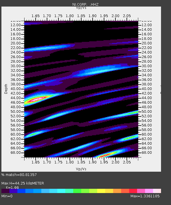
| Estimated Moho Depth: |
44.25 km |
| Estimated Crust Vp/Vs: |
1.66 |
| Assumed Crust Vp: |
6.155 km/s |
| Estimated Crust Vs: |
3.708 km/s |
| Estimated Crust Poisson's Ratio: |
0.22 |
|
| Radial Match: |
80.81357 % |
| Radial Bump: |
400 |
| Transverse Match: |
84.50671 % |
| Transverse Bump: |
400 |
| SOD ConfigId: |
739768 |
| Insert Time: |
2014-06-28 11:23:29.062 +0000 |
| GWidth: |
2.5 |
| Max Bumps: |
400 |
| Tol: |
0.001 |
|

Signal To Noise
| Channel | StoN | STA | LTA |
| NI:CGRP: :HHZ:20140614T11:23:27.78801Z | 20.564072 | 9.128148E-7 | 4.4388816E-8 |
| NI:CGRP: :HHN:20140614T11:23:27.78801Z | 3.7068064 | 2.1417793E-7 | 5.7779637E-8 |
| NI:CGRP: :HHE:20140614T11:23:27.78801Z | 7.8717794 | 5.9108766E-7 | 7.508946E-8 |
| Arrivals |
| Ps | 4.8 SECOND |
| PpPs | 19 SECOND |
| PsPs/PpSs | 24 SECOND |


