You are here: Home > Network List > II - Global Seismograph Network (GSN - IRIS/IDA) Stations List
> Station SUR Sutherland, South Africa > Earthquake Result Viewer
SUR Sutherland, South Africa - Earthquake Result Viewer
| Earthquake location: |
Windward Islands |
| Earthquake latitude/longitude: |
15.0/-61.3 |
| Earthquake time(UTC): |
2007/11/29 (333) 19:00:19 GMT |
| Earthquake Depth: |
148 km |
| Earthquake Magnitude: |
6.9 MB, 7.4 MW, 7.4 MW |
| Earthquake Catalog/Contributor: |
WHDF/NEIC |
|
| Network: |
II Global Seismograph Network (GSN - IRIS/IDA) |
| Station: |
SUR Sutherland, South Africa |
| Lat/Lon: |
32.38 S/20.81 E |
| Elevation: |
1770 m |
|
| Distance: |
91.4 deg |
| Az: |
123.039 deg |
| Baz: |
286.759 deg |
| Ray Param: |
0.041553184 |
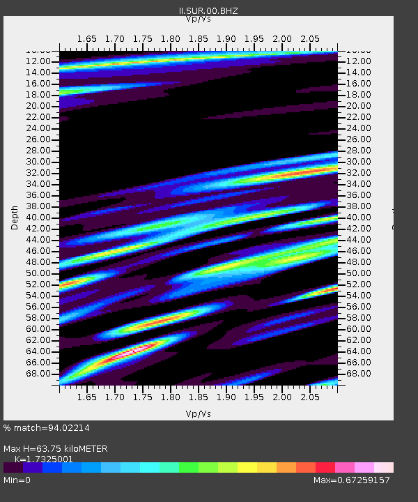
| Estimated Moho Depth: |
63.75 km |
| Estimated Crust Vp/Vs: |
1.73 |
| Assumed Crust Vp: |
6.51 km/s |
| Estimated Crust Vs: |
3.758 km/s |
| Estimated Crust Poisson's Ratio: |
0.25 |
|
| Radial Match: |
94.02214 % |
| Radial Bump: |
400 |
| Transverse Match: |
69.764046 % |
| Transverse Bump: |
400 |
| SOD ConfigId: |
2564 |
| Insert Time: |
2010-03-01 23:01:08.483 +0000 |
| GWidth: |
2.5 |
| Max Bumps: |
400 |
| Tol: |
0.001 |
|
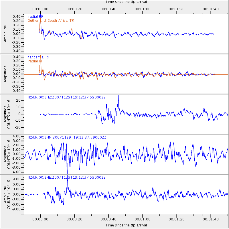
Signal To Noise
| Channel | StoN | STA | LTA |
| II:SUR:00:BHN:20071129T19:12:37.590002Z | 1.480191 | 6.507035E-7 | 4.3960782E-7 |
| II:SUR:00:BHE:20071129T19:12:37.590002Z | 3.4985428 | 1.1960457E-6 | 3.4186965E-7 |
| II:SUR:00:BHZ:20071129T19:12:37.590002Z | 4.39833 | 3.032323E-6 | 6.89426E-7 |
| Arrivals |
| Ps | 7.3 SECOND |
| PpPs | 26 SECOND |
| PsPs/PpSs | 34 SECOND |


