You are here: Home > Network List > II - Global Seismograph Network (GSN - IRIS/IDA) Stations List
> Station SUR Sutherland, South Africa > Earthquake Result Viewer
SUR Sutherland, South Africa - Earthquake Result Viewer
| Earthquake location: |
Afghanistan-Tajikistan Bord Reg. |
| Earthquake latitude/longitude: |
36.4/71.1 |
| Earthquake time(UTC): |
1991/07/14 (195) 09:09:13 GMT |
| Earthquake Depth: |
223 km |
| Earthquake Magnitude: |
6.4 MB |
| Earthquake Catalog/Contributor: |
WHDF/NEIC |
|
| Network: |
II Global Seismograph Network (GSN - IRIS/IDA) |
| Station: |
SUR Sutherland, South Africa |
| Lat/Lon: |
32.38 S/20.81 E |
| Elevation: |
1770 m |
|
| Distance: |
83.1 deg |
| Az: |
221.003 deg |
| Baz: |
38.727 deg |
| Ray Param: |
0.045908462 |
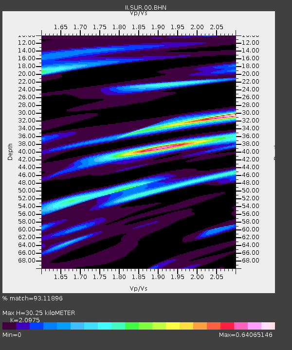
| Estimated Moho Depth: |
30.25 km |
| Estimated Crust Vp/Vs: |
2.10 |
| Assumed Crust Vp: |
6.51 km/s |
| Estimated Crust Vs: |
3.104 km/s |
| Estimated Crust Poisson's Ratio: |
0.35 |
|
| Radial Match: |
93.11896 % |
| Radial Bump: |
400 |
| Transverse Match: |
86.74881 % |
| Transverse Bump: |
400 |
| SOD ConfigId: |
4480 |
| Insert Time: |
2010-03-01 23:01:13.062 +0000 |
| GWidth: |
2.5 |
| Max Bumps: |
400 |
| Tol: |
0.001 |
|
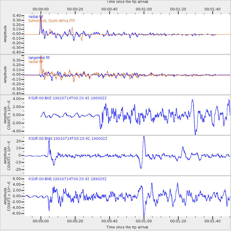
Signal To Noise
| Channel | StoN | STA | LTA |
| II:SUR:00:BHN:19910714T09:20:42.190002Z | 12.412139 | 5.908441E-6 | 4.7602117E-7 |
| II:SUR:00:BHE:19910714T09:20:42.189026Z | 3.5426648 | 1.1741894E-6 | 3.3144244E-7 |
| II:SUR:00:BHZ:19910714T09:20:42.190002Z | 2.4537866 | 8.33428E-7 | 3.3964974E-7 |
| Arrivals |
| Ps | 5.2 SECOND |
| PpPs | 14 SECOND |
| PsPs/PpSs | 19 SECOND |


