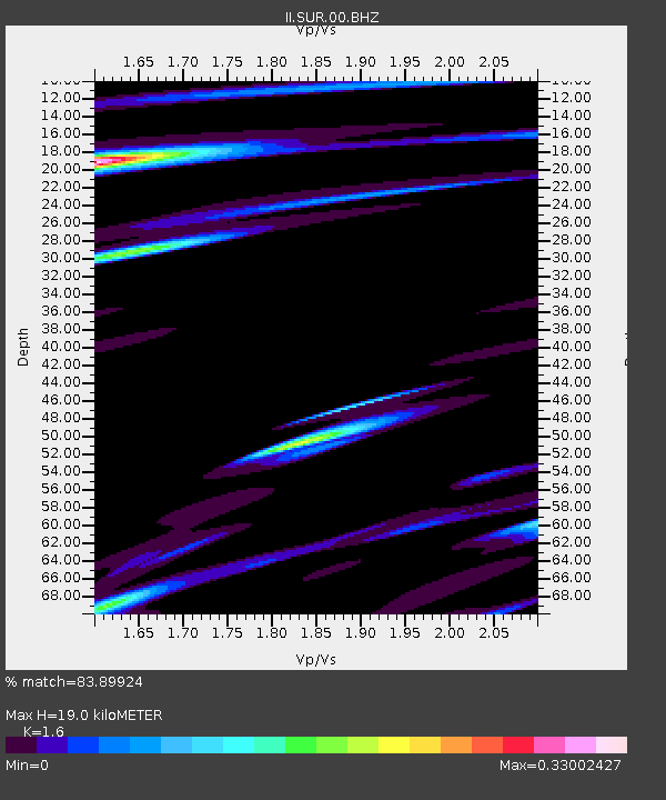
SUR Sutherland, South Africa - Earthquake Result Viewer

Earthquake location: South Sandwich Islands Region
Earthquake latitude/longitude: -58.7/-24.7
Earthquake time(UTC): 2008/04/28 (119) 15:57:55 GMT
Earthquake Depth: 35 km
Earthquake Magnitude: 5.5 MB, 5.9 MS, 6.1 MW, 6.0 MW
Earthquake Catalog/Contributor: WHDF/NEIC
Network: II Global Seismograph Network (GSN - IRIS/IDA)
Station: SUR Sutherland, South Africa
Lat/Lon: 32.38 S/20.81 E
Elevation: 1770 m
Distance: 40.2 deg
Az: 69.323 deg
Baz: 215.213 deg
Ray Param: 0.07447117
Estimated Moho Depth: 19.0 km
Estimated Crust Vp/Vs: 1.60
Assumed Crust Vp: 6.51 km/s
Estimated Crust Vs: 4.069 km/s
Estimated Crust Poisson's Ratio: 0.18
Radial Match: 83.89924 %
Radial Bump: 400
Transverse Match: 73.88467 %
Transverse Bump: 400
SOD ConfigId: 2504
Insert Time: 2010-03-01 23:01:15.850 +0000
GWidth: 2.5
Max Bumps: 400
Tol: 0.001

Signal To Noise

ChannelStoNSTALTA
II:SUR:00:BHN:20080428T16:04:57.851014Z3.80346049.158763E-72.408008E-7
II:SUR:00:BHE:20080428T16:04:57.851014Z0.953194563.17656E-73.3325412E-7
II:SUR:00:BHZ:20080428T16:04:57.851014Z0.83461592.2912668E-72.745295E-7
Arrivals
Ps1.9 SECOND
PpPs7.0 SECOND
PsPs/PpSs8.9 SECOND