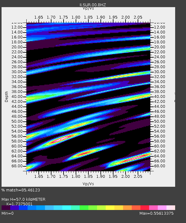
SUR Sutherland, South Africa - Earthquake Result Viewer

Earthquake location: South Sandwich Islands Region
Earthquake latitude/longitude: -58.2/-22.1
Earthquake time(UTC): 2008/06/30 (182) 06:17:44 GMT
Earthquake Depth: 19 km
Earthquake Magnitude: 6.1 MB, 6.7 MS, 7.0 MW, 6.9 MW
Earthquake Catalog/Contributor: WHDF/NEIC
Network: II Global Seismograph Network (GSN - IRIS/IDA)
Station: SUR Sutherland, South Africa
Lat/Lon: 32.38 S/20.81 E
Elevation: 1770 m
Distance: 38.7 deg
Az: 67.066 deg
Baz: 215.17 deg
Ray Param: 0.07537422
Estimated Moho Depth: 57.0 km
Estimated Crust Vp/Vs: 1.74
Assumed Crust Vp: 6.51 km/s
Estimated Crust Vs: 3.747 km/s
Estimated Crust Poisson's Ratio: 0.25
Radial Match: 85.46123 %
Radial Bump: 395
Transverse Match: 72.87312 %
Transverse Bump: 400
SOD ConfigId: 2504
Insert Time: 2010-03-01 23:01:18.611 +0000
GWidth: 2.5
Max Bumps: 400
Tol: 0.001

Signal To Noise

ChannelStoNSTALTA
II:SUR:00:BHN:20080630T06:24:36.926011Z2.85480051.827727E-66.4022936E-7
II:SUR:00:BHE:20080630T06:24:36.926011Z1.95060228.1387736E-74.1724414E-7
II:SUR:00:BHZ:20080630T06:24:36.926011Z2.0843187.268204E-73.4870902E-7
Arrivals
Ps7.0 SECOND
PpPs22 SECOND
PsPs/PpSs29 SECOND