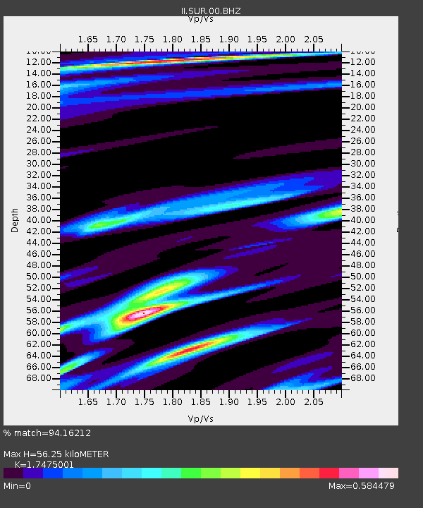
SUR Sutherland, South Africa - Earthquake Result Viewer
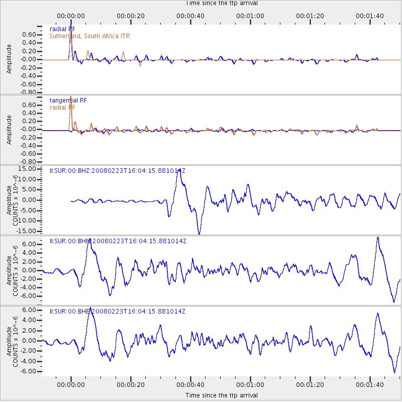
Earthquake location: South Sandwich Islands Region
Earthquake latitude/longitude: -57.3/-23.4
Earthquake time(UTC): 2008/02/23 (054) 15:57:19 GMT
Earthquake Depth: 10 km
Earthquake Magnitude: 6.2 MB, 6.7 MS, 6.7 MW, 6.7 MW
Earthquake Catalog/Contributor: WHDF/NEIC
Network: II Global Seismograph Network (GSN - IRIS/IDA)
Station: SUR Sutherland, South Africa
Lat/Lon: 32.38 S/20.81 E
Elevation: 1770 m
Distance: 39.0 deg
Az: 69.538 deg
Baz: 216.914 deg
Ray Param: 0.07520861
Estimated Moho Depth: 56.25 km
Estimated Crust Vp/Vs: 1.75
Assumed Crust Vp: 6.51 km/s
Estimated Crust Vs: 3.725 km/s
Estimated Crust Poisson's Ratio: 0.26
Radial Match: 94.16212 %
Radial Bump: 208
Transverse Match: 69.21753 %
Transverse Bump: 400
SOD ConfigId: 2564
Insert Time: 2010-03-01 23:01:20.771 +0000
GWidth: 2.5
Max Bumps: 400
Tol: 0.001

Signal To Noise

ChannelStoNSTALTA
II:SUR:00:BHN:20080223T16:04:15.881014Z4.48592331.53806E-63.4286364E-7
II:SUR:00:BHE:20080223T16:04:15.881014Z3.4894021.0819768E-63.1007514E-7
II:SUR:00:BHZ:20080223T16:04:15.881014Z7.5477513.2608684E-64.320318E-7
Arrivals
Ps7.0 SECOND
PpPs22 SECOND
PsPs/PpSs29 SECOND