You are here: Home > Network List > II - Global Seismograph Network (GSN - IRIS/IDA) Stations List
> Station SUR Sutherland, South Africa > Earthquake Result Viewer
SUR Sutherland, South Africa - Earthquake Result Viewer
| Earthquake location: |
Hindu Kush Region, Afghanistan |
| Earthquake latitude/longitude: |
36.1/70.5 |
| Earthquake time(UTC): |
1991/01/31 (031) 23:03:34 GMT |
| Earthquake Depth: |
152 km |
| Earthquake Magnitude: |
6.4 MB, 6.6 UNKNOWN |
| Earthquake Catalog/Contributor: |
WHDF/NEIC |
|
| Network: |
II Global Seismograph Network (GSN - IRIS/IDA) |
| Station: |
SUR Sutherland, South Africa |
| Lat/Lon: |
32.38 S/20.81 E |
| Elevation: |
1770 m |
|
| Distance: |
82.5 deg |
| Az: |
220.594 deg |
| Baz: |
38.544 deg |
| Ray Param: |
0.046525363 |
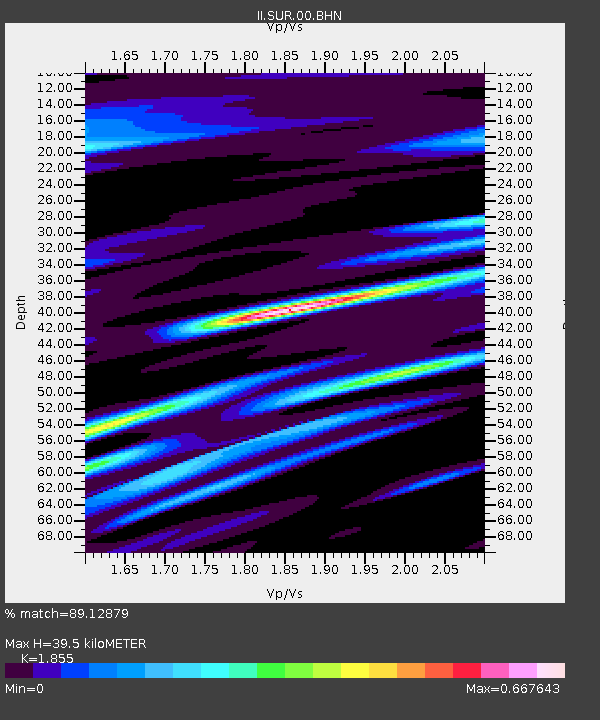
| Estimated Moho Depth: |
39.5 km |
| Estimated Crust Vp/Vs: |
1.86 |
| Assumed Crust Vp: |
6.51 km/s |
| Estimated Crust Vs: |
3.51 km/s |
| Estimated Crust Poisson's Ratio: |
0.30 |
|
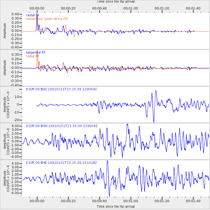
| Radial Match: |
89.12879 % |
| Radial Bump: |
400 |
| Transverse Match: |
73.783295 % |
| Transverse Bump: |
400 |
| SOD ConfigId: |
61242 |
| Insert Time: |
2010-03-01 23:01:23.300 +0000 |
| GWidth: |
2.5 |
| Max Bumps: |
400 |
| Tol: |
0.001 |
|
Signal To Noise
| Channel | StoN | STA | LTA |
| II:SUR:00:BHN:19910131T23:15:09.129004Z | 0.9218766 | 4.430268E-7 | 4.8057063E-7 |
| II:SUR:00:BHE:19910131T23:15:09.131018Z | 1.4154613 | 5.713378E-7 | 4.0364074E-7 |
| II:SUR:00:BHZ:19910131T23:15:09.129004Z | 1.3863478 | 9.3662106E-7 | 6.7560325E-7 |
| Arrivals |
| Ps | 5.3 SECOND |
| PpPs | 17 SECOND |
| PsPs/PpSs | 22 SECOND |


