You are here: Home > Network List > II - Global Seismograph Network (GSN - IRIS/IDA) Stations List
> Station SUR Sutherland, South Africa > Earthquake Result Viewer
SUR Sutherland, South Africa - Earthquake Result Viewer
| Earthquake location: |
South Sandwich Islands Region |
| Earthquake latitude/longitude: |
-56.7/-26.5 |
| Earthquake time(UTC): |
1992/11/21 (326) 22:39:35 GMT |
| Earthquake Depth: |
33 km |
| Earthquake Magnitude: |
5.9 MB, 6.6 MS |
| Earthquake Catalog/Contributor: |
WHDF/NEIC |
|
| Network: |
II Global Seismograph Network (GSN - IRIS/IDA) |
| Station: |
SUR Sutherland, South Africa |
| Lat/Lon: |
32.38 S/20.81 E |
| Elevation: |
1770 m |
|
| Distance: |
40.5 deg |
| Az: |
73.562 deg |
| Baz: |
218.745 deg |
| Ray Param: |
0.074324444 |
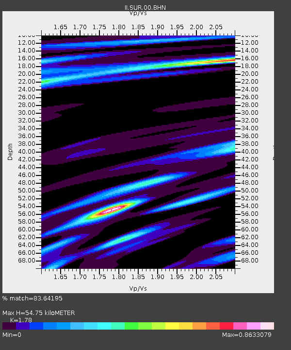
| Estimated Moho Depth: |
54.75 km |
| Estimated Crust Vp/Vs: |
1.78 |
| Assumed Crust Vp: |
6.51 km/s |
| Estimated Crust Vs: |
3.657 km/s |
| Estimated Crust Poisson's Ratio: |
0.27 |
|
| Radial Match: |
83.64195 % |
| Radial Bump: |
307 |
| Transverse Match: |
55.65136 % |
| Transverse Bump: |
400 |
| SOD ConfigId: |
61242 |
| Insert Time: |
2010-03-01 23:01:29.659 +0000 |
| GWidth: |
2.5 |
| Max Bumps: |
400 |
| Tol: |
0.001 |
|
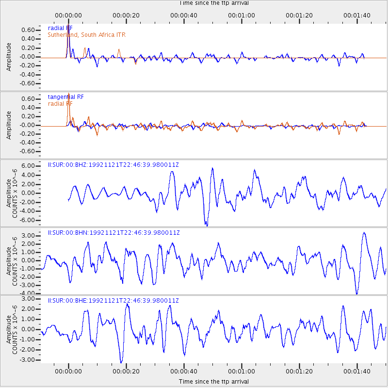
Signal To Noise
| Channel | StoN | STA | LTA |
| II:SUR:00:BHN:19921121T22:46:39.980011Z | 1.8257661 | 1.2254102E-6 | 6.711759E-7 |
| II:SUR:00:BHE:19921121T22:46:39.980011Z | 1.155909 | 7.5129645E-7 | 6.4996163E-7 |
| II:SUR:00:BHZ:19921121T22:46:39.980011Z | 1.9800063 | 1.9573274E-6 | 9.88546E-7 |
| Arrivals |
| Ps | 7.0 SECOND |
| PpPs | 22 SECOND |
| PsPs/PpSs | 29 SECOND |


