You are here: Home > Network List > II - Global Seismograph Network (GSN - IRIS/IDA) Stations List
> Station SUR Sutherland, South Africa > Earthquake Result Viewer
SUR Sutherland, South Africa - Earthquake Result Viewer
| Earthquake location: |
South Sandwich Islands Region |
| Earthquake latitude/longitude: |
-59.4/-26.3 |
| Earthquake time(UTC): |
1993/01/10 (010) 14:39:03 GMT |
| Earthquake Depth: |
84 km |
| Earthquake Magnitude: |
6.3 MB |
| Earthquake Catalog/Contributor: |
WHDF/NEIC |
|
| Network: |
II Global Seismograph Network (GSN - IRIS/IDA) |
| Station: |
SUR Sutherland, South Africa |
| Lat/Lon: |
32.38 S/20.81 E |
| Elevation: |
1770 m |
|
| Distance: |
41.2 deg |
| Az: |
70.312 deg |
| Baz: |
214.736 deg |
| Ray Param: |
0.07367518 |
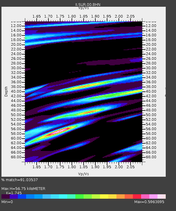
| Estimated Moho Depth: |
56.75 km |
| Estimated Crust Vp/Vs: |
1.75 |
| Assumed Crust Vp: |
6.51 km/s |
| Estimated Crust Vs: |
3.731 km/s |
| Estimated Crust Poisson's Ratio: |
0.26 |
|
| Radial Match: |
91.03537 % |
| Radial Bump: |
400 |
| Transverse Match: |
74.39212 % |
| Transverse Bump: |
400 |
| SOD ConfigId: |
61242 |
| Insert Time: |
2010-03-01 23:01:31.553 +0000 |
| GWidth: |
2.5 |
| Max Bumps: |
400 |
| Tol: |
0.001 |
|
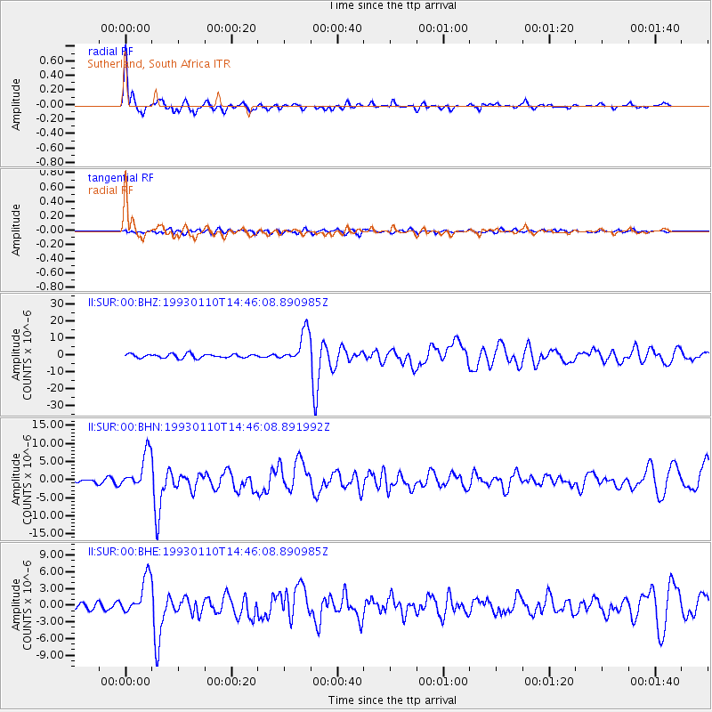
Signal To Noise
| Channel | StoN | STA | LTA |
| II:SUR:00:BHN:19930110T14:46:08.891992Z | 8.44016 | 5.071878E-6 | 6.00922E-7 |
| II:SUR:00:BHE:19930110T14:46:08.890985Z | 7.6582446 | 3.4068976E-6 | 4.4486666E-7 |
| II:SUR:00:BHZ:19930110T14:46:08.890985Z | 8.323657 | 9.52872E-6 | 1.1447755E-6 |
| Arrivals |
| Ps | 7.0 SECOND |
| PpPs | 22 SECOND |
| PsPs/PpSs | 29 SECOND |


