You are here: Home > Network List > II - Global Seismograph Network (GSN - IRIS/IDA) Stations List
> Station SUR Sutherland, South Africa > Earthquake Result Viewer
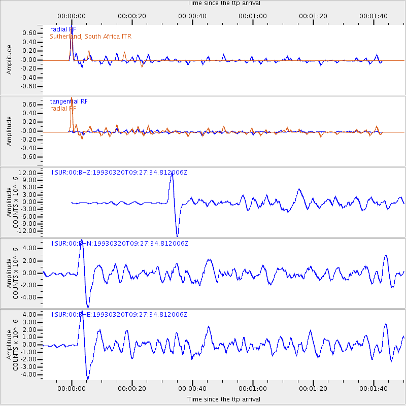
SUR Sutherland, South Africa - Earthquake Result Viewer
| Earthquake location: |
South Sandwich Islands Region |
| Earthquake latitude/longitude: |
-56.1/-27.9 |
| Earthquake time(UTC): |
1993/03/20 (079) 09:20:34 GMT |
| Earthquake Depth: |
130 km |
| Earthquake Magnitude: |
5.9 MB |
| Earthquake Catalog/Contributor: |
WHDF/NEIC |
|
| Network: |
II Global Seismograph Network (GSN - IRIS/IDA) |
| Station: |
SUR Sutherland, South Africa |
| Lat/Lon: |
32.38 S/20.81 E |
| Elevation: |
1770 m |
|
| Distance: |
41.0 deg |
| Az: |
75.594 deg |
| Baz: |
219.918 deg |
| Ray Param: |
0.07355595 |
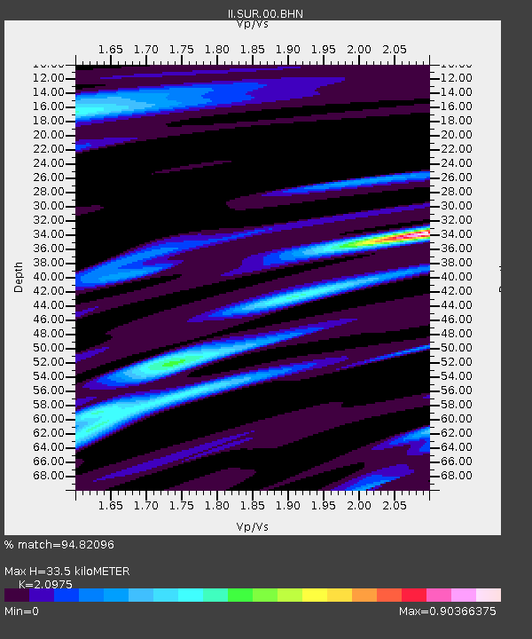
| Estimated Moho Depth: |
33.5 km |
| Estimated Crust Vp/Vs: |
2.10 |
| Assumed Crust Vp: |
6.51 km/s |
| Estimated Crust Vs: |
3.104 km/s |
| Estimated Crust Poisson's Ratio: |
0.35 |
|
| Radial Match: |
94.82096 % |
| Radial Bump: |
288 |
| Transverse Match: |
67.834015 % |
| Transverse Bump: |
400 |
| SOD ConfigId: |
61242 |
| Insert Time: |
2010-03-01 23:01:34.081 +0000 |
| GWidth: |
2.5 |
| Max Bumps: |
400 |
| Tol: |
0.001 |
|
Signal To Noise
| Channel | StoN | STA | LTA |
| II:SUR:00:BHN:19930320T09:27:34.812006Z | 13.173834 | 2.5956263E-6 | 1.9702891E-7 |
| II:SUR:00:BHE:19930320T09:27:34.812006Z | 13.679271 | 2.105435E-6 | 1.5391427E-7 |
| II:SUR:00:BHZ:19930320T09:27:34.812006Z | 18.93583 | 6.1178016E-6 | 3.2308074E-7 |
| Arrivals |
| Ps | 6.0 SECOND |
| PpPs | 15 SECOND |
| PsPs/PpSs | 21 SECOND |


