You are here: Home > Network List > TA - USArray Transportable Network (new EarthScope stations) Stations List
> Station M53A WI Miller and Sons, Farmdale, OH, USA > Earthquake Result Viewer
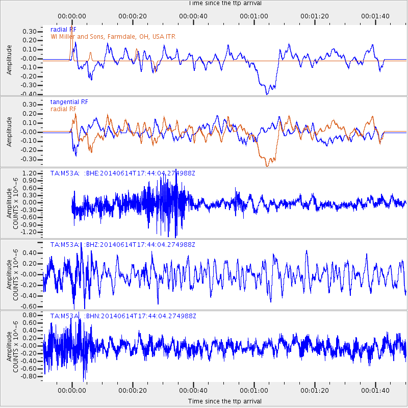
M53A WI Miller and Sons, Farmdale, OH, USA - Earthquake Result Viewer
*The percent match for this event was below the threshold and hence no stack was calculated.
| Earthquake location: |
Eastern Honshu, Japan |
| Earthquake latitude/longitude: |
39.5/141.0 |
| Earthquake time(UTC): |
2014/06/14 (165) 17:31:41 GMT |
| Earthquake Depth: |
92 km |
| Earthquake Magnitude: |
5.6 MWB, 5.6 MWC |
| Earthquake Catalog/Contributor: |
NEIC PDE/NEIC COMCAT |
|
| Network: |
TA USArray Transportable Network (new EarthScope stations) |
| Station: |
M53A WI Miller and Sons, Farmdale, OH, USA |
| Lat/Lon: |
41.44 N/80.68 W |
| Elevation: |
334 m |
|
| Distance: |
91.0 deg |
| Az: |
29.985 deg |
| Baz: |
329.027 deg |
| Ray Param: |
$rayparam |
*The percent match for this event was below the threshold and hence was not used in the summary stack. |
|
| Radial Match: |
52.652287 % |
| Radial Bump: |
400 |
| Transverse Match: |
29.99957 % |
| Transverse Bump: |
400 |
| SOD ConfigId: |
739768 |
| Insert Time: |
2014-06-28 18:05:36.966 +0000 |
| GWidth: |
2.5 |
| Max Bumps: |
400 |
| Tol: |
0.001 |
|
Signal To Noise
| Channel | StoN | STA | LTA |
| TA:M53A: :BHZ:20140614T17:44:04.274988Z | 1.4901383 | 2.6271647E-7 | 1.7630342E-7 |
| TA:M53A: :BHN:20140614T17:44:04.274988Z | 1.3823063 | 3.5708166E-7 | 2.583231E-7 |
| TA:M53A: :BHE:20140614T17:44:04.274988Z | 2.4218028 | 6.4415724E-7 | 2.6598255E-7 |
| Arrivals |
| Ps | |
| PpPs | |
| PsPs/PpSs | |


