You are here: Home > Network List > CN - Canadian National Seismograph Network Stations List
> Station INK INUVIK, NT > Earthquake Result Viewer
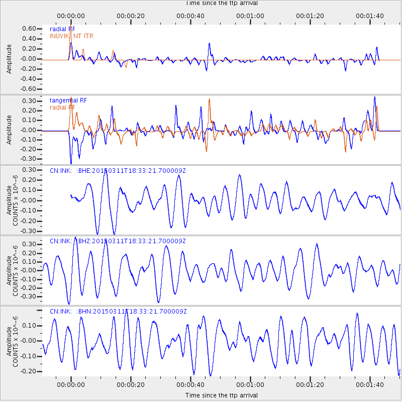
INK INUVIK, NT - Earthquake Result Viewer
*The percent match for this event was below the threshold and hence no stack was calculated.
| Earthquake location: |
Hokkaido, Japan Region |
| Earthquake latitude/longitude: |
43.2/145.3 |
| Earthquake time(UTC): |
2015/03/11 (070) 18:25:24 GMT |
| Earthquake Depth: |
70 km |
| Earthquake Magnitude: |
3.7 mb |
| Earthquake Catalog/Contributor: |
ISC/ISC |
|
| Network: |
CN Canadian National Seismograph Network |
| Station: |
INK INUVIK, NT |
| Lat/Lon: |
68.31 N/133.53 W |
| Elevation: |
44 m |
|
| Distance: |
47.5 deg |
| Az: |
29.886 deg |
| Baz: |
281.688 deg |
| Ray Param: |
$rayparam |
*The percent match for this event was below the threshold and hence was not used in the summary stack. |
|
| Radial Match: |
49.859776 % |
| Radial Bump: |
400 |
| Transverse Match: |
52.177696 % |
| Transverse Bump: |
400 |
| SOD ConfigId: |
7019011 |
| Insert Time: |
2019-04-17 07:15:37.918 +0000 |
| GWidth: |
2.5 |
| Max Bumps: |
400 |
| Tol: |
0.001 |
|
Signal To Noise
| Channel | StoN | STA | LTA |
| CN:INK: :BHZ:20150311T18:33:21.700009Z | 2.1955187 | 2.5689275E-7 | 1.1700777E-7 |
| CN:INK: :BHN:20150311T18:33:21.700009Z | 1.079882 | 1.0826657E-7 | 1.0025777E-7 |
| CN:INK: :BHE:20150311T18:33:21.700009Z | 0.96383756 | 1.3443771E-7 | 1.3948171E-7 |
| Arrivals |
| Ps | |
| PpPs | |
| PsPs/PpSs | |


