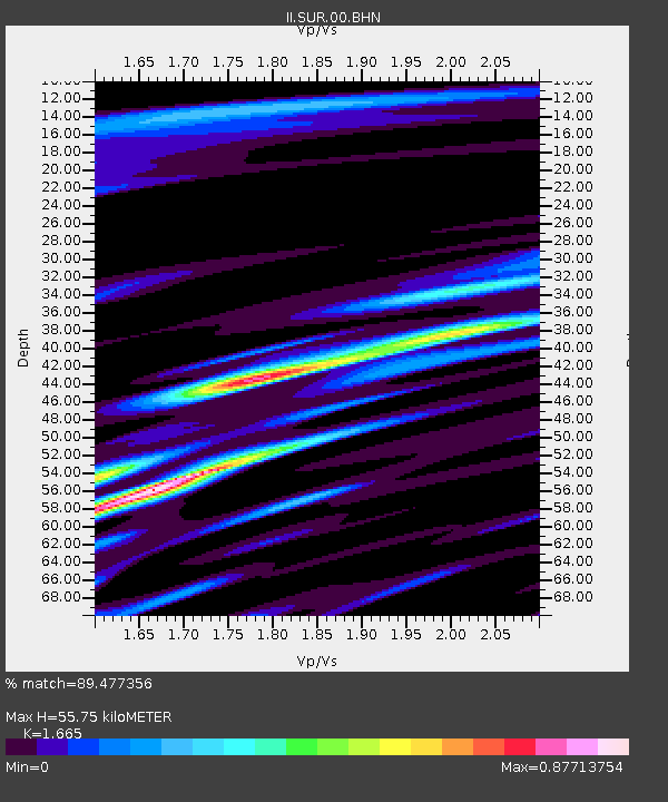
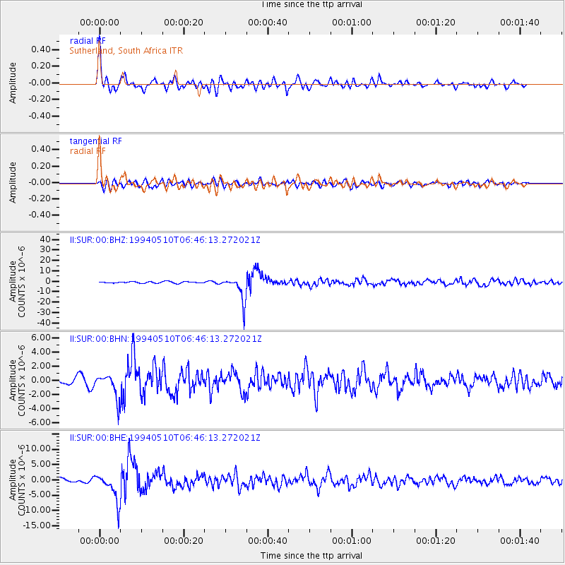
SUR Sutherland, South Africa - Earthquake Result Viewer

Earthquake location: Santiago Del Estero Prov., Arg.
Earthquake latitude/longitude: -28.5/-63.1
Earthquake time(UTC): 1994/05/10 (130) 06:36:28 GMT
Earthquake Depth: 605 km
Earthquake Magnitude: 6.4 MB, 6.2 UNKNOWN, 6.9 MW
Earthquake Catalog/Contributor: WHDF/NEIC
Network: II Global Seismograph Network (GSN - IRIS/IDA)
Station: SUR Sutherland, South Africa
Lat/Lon: 32.38 S/20.81 E
Elevation: 1770 m
Distance: 70.6 deg
Az: 116.868 deg
Baz: 248.115 deg
Ray Param: 0.05279393
Estimated Moho Depth: 55.75 km
Estimated Crust Vp/Vs: 1.66
Assumed Crust Vp: 6.51 km/s
Estimated Crust Vs: 3.91 km/s
Estimated Crust Poisson's Ratio: 0.22
Radial Match: 89.477356 %
Radial Bump: 400
Transverse Match: 72.329346 %
Transverse Bump: 400
SOD ConfigId: 61242
Insert Time: 2010-03-01 23:01:43.450 +0000
GWidth: 2.5
Max Bumps: 400
Tol: 0.001

Signal To Noise

ChannelStoNSTALTA
II:SUR:00:BHN:19940510T06:46:13.272021Z3.63344431.7952556E-64.94092E-7
II:SUR:00:BHE:19940510T06:46:13.272021Z7.5452854.822757E-66.391749E-7
II:SUR:00:BHZ:19940510T06:46:13.272021Z16.9547581.2404337E-57.3161397E-7
Arrivals
Ps5.9 SECOND
PpPs22 SECOND
PsPs/PpSs28 SECOND