You are here: Home > Network List > TA - USArray Transportable Network (new EarthScope stations) Stations List
> Station X43A Marvell, AR, USA > Earthquake Result Viewer
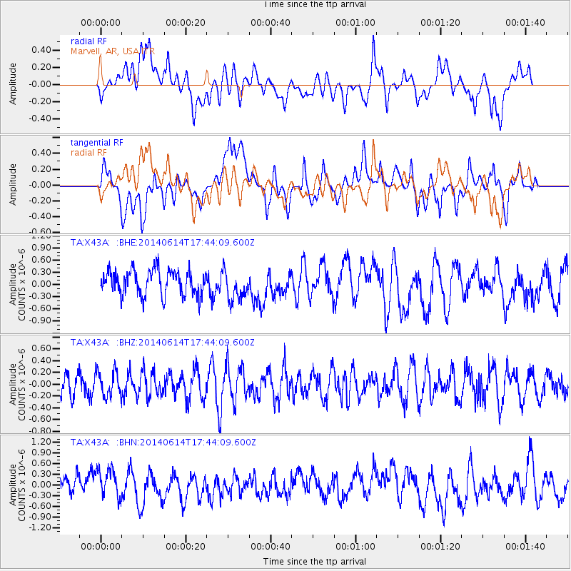
X43A Marvell, AR, USA - Earthquake Result Viewer
*The percent match for this event was below the threshold and hence no stack was calculated.
| Earthquake location: |
Eastern Honshu, Japan |
| Earthquake latitude/longitude: |
39.5/141.0 |
| Earthquake time(UTC): |
2014/06/14 (165) 17:31:41 GMT |
| Earthquake Depth: |
92 km |
| Earthquake Magnitude: |
5.6 MWB, 5.6 MWC |
| Earthquake Catalog/Contributor: |
NEIC PDE/NEIC COMCAT |
|
| Network: |
TA USArray Transportable Network (new EarthScope stations) |
| Station: |
X43A Marvell, AR, USA |
| Lat/Lon: |
34.52 N/90.88 W |
| Elevation: |
53 m |
|
| Distance: |
92.2 deg |
| Az: |
40.533 deg |
| Baz: |
322.458 deg |
| Ray Param: |
$rayparam |
*The percent match for this event was below the threshold and hence was not used in the summary stack. |
|
| Radial Match: |
35.761276 % |
| Radial Bump: |
400 |
| Transverse Match: |
55.159378 % |
| Transverse Bump: |
400 |
| SOD ConfigId: |
739768 |
| Insert Time: |
2014-06-28 18:07:54.683 +0000 |
| GWidth: |
2.5 |
| Max Bumps: |
400 |
| Tol: |
0.001 |
|
Signal To Noise
| Channel | StoN | STA | LTA |
| TA:X43A: :BHZ:20140614T17:44:09.600Z | 0.99348724 | 2.0716004E-7 | 2.0851807E-7 |
| TA:X43A: :BHN:20140614T17:44:09.600Z | 1.0331484 | 4.1471102E-7 | 4.0140512E-7 |
| TA:X43A: :BHE:20140614T17:44:09.600Z | 1.2114121 | 3.7301317E-7 | 3.0791603E-7 |
| Arrivals |
| Ps | |
| PpPs | |
| PsPs/PpSs | |


