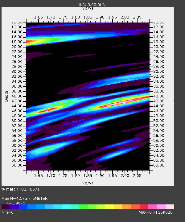
SUR Sutherland, South Africa - Earthquake Result Viewer
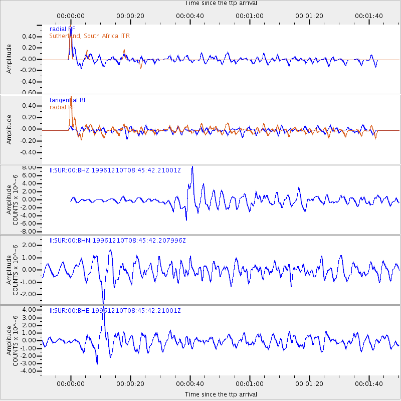
Earthquake location: Central Mid-Atlantic Ridge
Earthquake latitude/longitude: 0.9/-30.0
Earthquake time(UTC): 1996/12/10 (345) 08:36:18 GMT
Earthquake Depth: 10 km
Earthquake Magnitude: 6.0 MB, 6.2 MS, 6.6 UNKNOWN, 6.6 MW
Earthquake Catalog/Contributor: WHDF/NEIC
Network: II Global Seismograph Network (GSN - IRIS/IDA)
Station: SUR Sutherland, South Africa
Lat/Lon: 32.38 S/20.81 E
Elevation: 1770 m
Distance: 58.3 deg
Az: 129.502 deg
Baz: 294.244 deg
Ray Param: 0.06296221
Estimated Moho Depth: 42.75 km
Estimated Crust Vp/Vs: 1.97
Assumed Crust Vp: 6.51 km/s
Estimated Crust Vs: 3.309 km/s
Estimated Crust Poisson's Ratio: 0.33
Radial Match: 82.70571 %
Radial Bump: 400
Transverse Match: 60.968407 %
Transverse Bump: 400
SOD ConfigId: 6273
Insert Time: 2010-03-01 23:01:51.117 +0000
GWidth: 2.5
Max Bumps: 400
Tol: 0.001

Signal To Noise

ChannelStoNSTALTA
II:SUR:00:BHN:19961210T08:45:42.207996Z1.61383554.962485E-73.0749632E-7
II:SUR:00:BHE:19961210T08:45:42.21001Z1.69855075.832831E-73.4340047E-7
II:SUR:00:BHZ:19961210T08:45:42.21001Z2.75674821.0161814E-63.6861596E-7
Arrivals
Ps6.6 SECOND
PpPs19 SECOND
PsPs/PpSs25 SECOND