You are here: Home > Network List > II - Global Seismograph Network (GSN - IRIS/IDA) Stations List
> Station SUR Sutherland, South Africa > Earthquake Result Viewer
SUR Sutherland, South Africa - Earthquake Result Viewer
| Earthquake location: |
Southern Bolivia |
| Earthquake latitude/longitude: |
-22.0/-65.7 |
| Earthquake time(UTC): |
1997/01/23 (023) 02:15:22 GMT |
| Earthquake Depth: |
276 km |
| Earthquake Magnitude: |
6.4 MB, 7.1 UNKNOWN, 7.1 MW |
| Earthquake Catalog/Contributor: |
WHDF/NEIC |
|
| Network: |
II Global Seismograph Network (GSN - IRIS/IDA) |
| Station: |
SUR Sutherland, South Africa |
| Lat/Lon: |
32.38 S/20.81 E |
| Elevation: |
1770 m |
|
| Distance: |
75.8 deg |
| Az: |
119.382 deg |
| Baz: |
252.888 deg |
| Ray Param: |
0.050696727 |
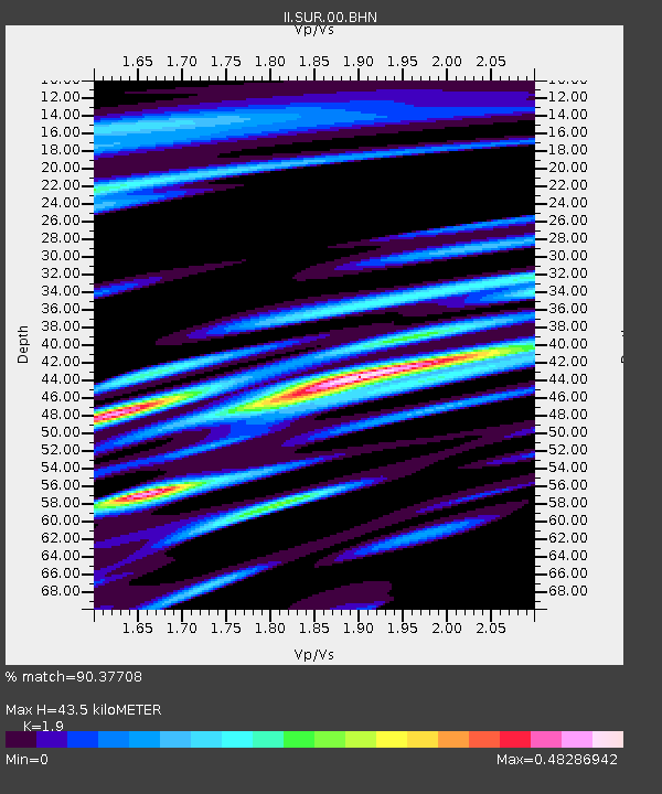
| Estimated Moho Depth: |
43.5 km |
| Estimated Crust Vp/Vs: |
1.90 |
| Assumed Crust Vp: |
6.51 km/s |
| Estimated Crust Vs: |
3.426 km/s |
| Estimated Crust Poisson's Ratio: |
0.31 |
|
| Radial Match: |
90.37708 % |
| Radial Bump: |
400 |
| Transverse Match: |
59.20445 % |
| Transverse Bump: |
400 |
| SOD ConfigId: |
6273 |
| Insert Time: |
2010-03-01 23:01:53.283 +0000 |
| GWidth: |
2.5 |
| Max Bumps: |
400 |
| Tol: |
0.001 |
|
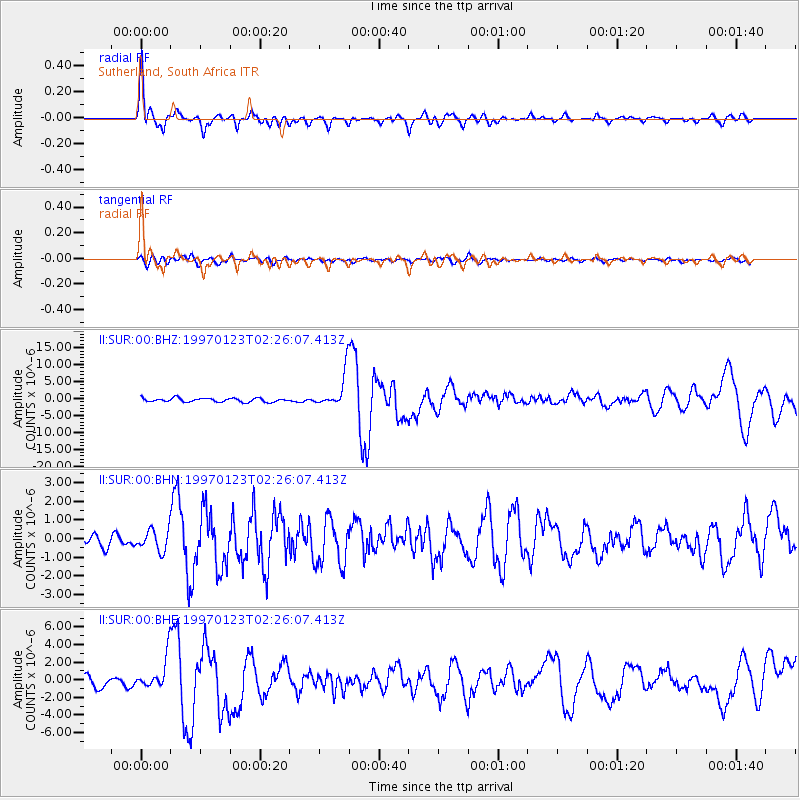
Signal To Noise
| Channel | StoN | STA | LTA |
| II:SUR:00:BHN:19970123T02:26:07.413Z | 1.5250578 | 5.642057E-7 | 3.6995698E-7 |
| II:SUR:00:BHE:19970123T02:26:07.413Z | 2.6622415 | 1.8466126E-6 | 6.9363074E-7 |
| II:SUR:00:BHZ:19970123T02:26:07.413Z | 9.069157 | 5.109269E-6 | 5.6336756E-7 |
| Arrivals |
| Ps | 6.2 SECOND |
| PpPs | 19 SECOND |
| PsPs/PpSs | 25 SECOND |


