You are here: Home > Network List > II - Global Seismograph Network (GSN - IRIS/IDA) Stations List
> Station SUR Sutherland, South Africa > Earthquake Result Viewer
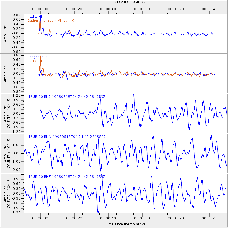
SUR Sutherland, South Africa - Earthquake Result Viewer

| Earthquake location: |
Ascension Island Region |
| Earthquake latitude/longitude: |
-11.6/-13.9 |
| Earthquake time(UTC): |
1998/06/18 (169) 04:17:54 GMT |
| Earthquake Depth: |
10 km |
| Earthquake Magnitude: |
6.1 MS, 5.4 MB, 6.2 UNKNOWN |
| Earthquake Catalog/Contributor: |
WHDF/NEIC |
|
| Network: |
II Global Seismograph Network (GSN - IRIS/IDA) |
| Station: |
SUR Sutherland, South Africa |
| Lat/Lon: |
32.38 S/20.81 E |
| Elevation: |
1770 m |
|
| Distance: |
38.0 deg |
| Az: |
128.531 deg |
| Baz: |
295.045 deg |
| Ray Param: |
0.07580736 |
| Estimated Moho Depth: |
12.75 km |
| Estimated Crust Vp/Vs: |
1.83 |
| Assumed Crust Vp: |
6.51 km/s |
| Estimated Crust Vs: |
3.562 km/s |
| Estimated Crust Poisson's Ratio: |
0.29 |
|
| Radial Match: |
83.0104 % |
| Radial Bump: |
364 |
| Transverse Match: |
68.5887 % |
| Transverse Bump: |
400 |
| SOD ConfigId: |
4480 |
| Insert Time: |
2010-03-01 23:01:55.342 +0000 |
| GWidth: |
2.5 |
| Max Bumps: |
400 |
| Tol: |
0.001 |
|
Signal To Noise
| Channel | StoN | STA | LTA |
| II:SUR:00:BHN:19980618T04:24:42.281989Z | 2.5210567 | 9.590926E-7 | 3.8043282E-7 |
| II:SUR:00:BHE:19980618T04:24:42.281989Z | 1.0045059 | 4.2655972E-7 | 4.2464632E-7 |
| II:SUR:00:BHZ:19980618T04:24:42.281989Z | 1.5997094 | 3.2303095E-7 | 2.0193102E-7 |
| Arrivals |
| Ps | 1.7 SECOND |
| PpPs | 5.1 SECOND |
| PsPs/PpSs | 6.9 SECOND |


