You are here: Home > Network List > II - Global Seismograph Network (GSN - IRIS/IDA) Stations List
> Station SUR Sutherland, South Africa > Earthquake Result Viewer
SUR Sutherland, South Africa - Earthquake Result Viewer
| Earthquake location: |
South Indian Ocean |
| Earthquake latitude/longitude: |
-13.8/97.5 |
| Earthquake time(UTC): |
2000/06/18 (170) 14:44:13 GMT |
| Earthquake Depth: |
10 km |
| Earthquake Magnitude: |
6.8 MB, 7.8 MS, 7.8 MW, 7.6 MW |
| Earthquake Catalog/Contributor: |
WHDF/NEIC |
|
| Network: |
II Global Seismograph Network (GSN - IRIS/IDA) |
| Station: |
SUR Sutherland, South Africa |
| Lat/Lon: |
32.38 S/20.81 E |
| Elevation: |
1770 m |
|
| Distance: |
71.6 deg |
| Az: |
240.203 deg |
| Baz: |
94.895 deg |
| Ray Param: |
0.05424505 |
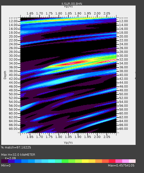
| Estimated Moho Depth: |
32.0 km |
| Estimated Crust Vp/Vs: |
2.09 |
| Assumed Crust Vp: |
6.51 km/s |
| Estimated Crust Vs: |
3.115 km/s |
| Estimated Crust Poisson's Ratio: |
0.35 |
|
| Radial Match: |
97.18225 % |
| Radial Bump: |
400 |
| Transverse Match: |
85.54962 % |
| Transverse Bump: |
400 |
| SOD ConfigId: |
3744 |
| Insert Time: |
2010-03-01 23:02:11.967 +0000 |
| GWidth: |
2.5 |
| Max Bumps: |
400 |
| Tol: |
0.001 |
|
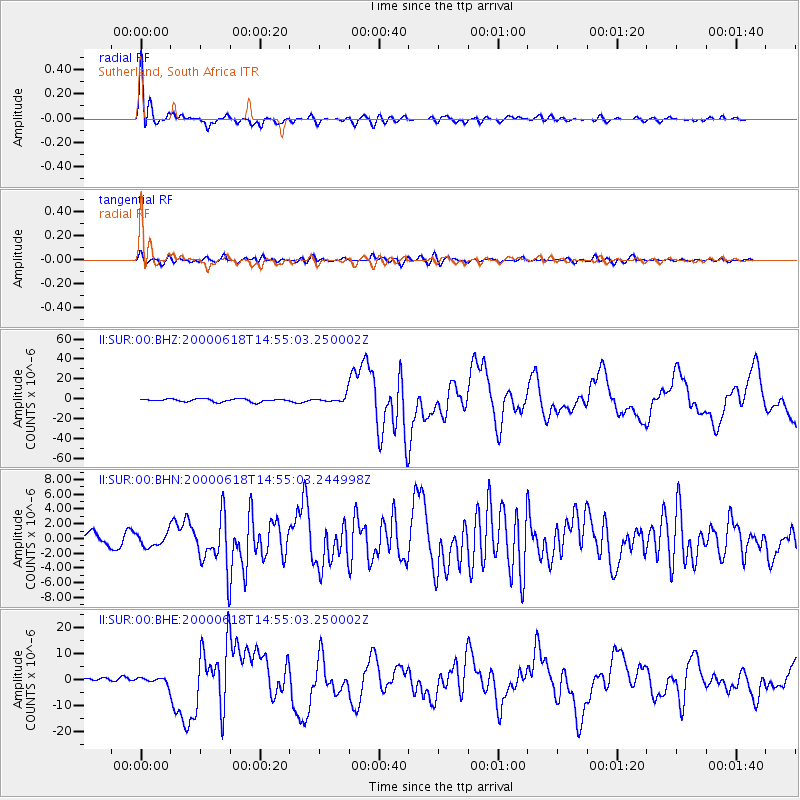
Signal To Noise
| Channel | StoN | STA | LTA |
| II:SUR:00:BHN:20000618T14:55:03.244998Z | 0.8013127 | 8.8860224E-7 | 1.1089331E-6 |
| II:SUR:00:BHE:20000618T14:55:03.250002Z | 2.1862612 | 1.3551443E-6 | 6.198456E-7 |
| II:SUR:00:BHZ:20000618T14:55:03.250002Z | 2.1519432 | 3.2884075E-6 | 1.5281107E-6 |
| Arrivals |
| Ps | 5.5 SECOND |
| PpPs | 15 SECOND |
| PsPs/PpSs | 20 SECOND |


