You are here: Home > Network List > TA - USArray Transportable Network (new EarthScope stations) Stations List
> Station P56A Dayton Farm, Ripley, WV, USA > Earthquake Result Viewer
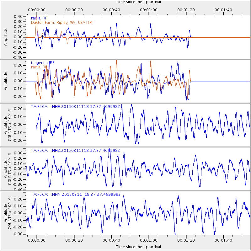
P56A Dayton Farm, Ripley, WV, USA - Earthquake Result Viewer
*The percent match for this event was below the threshold and hence no stack was calculated.
| Earthquake location: |
Hokkaido, Japan Region |
| Earthquake latitude/longitude: |
43.2/145.3 |
| Earthquake time(UTC): |
2015/03/11 (070) 18:25:24 GMT |
| Earthquake Depth: |
70 km |
| Earthquake Magnitude: |
3.7 mb |
| Earthquake Catalog/Contributor: |
ISC/ISC |
|
| Network: |
TA USArray Transportable Network (new EarthScope stations) |
| Station: |
P56A Dayton Farm, Ripley, WV, USA |
| Lat/Lon: |
39.50 N/78.84 W |
| Elevation: |
249 m |
|
| Distance: |
88.4 deg |
| Az: |
32.637 deg |
| Baz: |
329.379 deg |
| Ray Param: |
$rayparam |
*The percent match for this event was below the threshold and hence was not used in the summary stack. |
|
| Radial Match: |
57.17395 % |
| Radial Bump: |
400 |
| Transverse Match: |
52.654102 % |
| Transverse Bump: |
400 |
| SOD ConfigId: |
7019011 |
| Insert Time: |
2019-04-17 07:20:57.548 +0000 |
| GWidth: |
2.5 |
| Max Bumps: |
400 |
| Tol: |
0.001 |
|
Signal To Noise
| Channel | StoN | STA | LTA |
| TA:P56A: :HHZ:20150311T18:37:37.469998Z | 0.5276783 | 4.852838E-8 | 9.196584E-8 |
| TA:P56A: :HHN:20150311T18:37:37.469998Z | 0.9300609 | 1.0152209E-7 | 1.0915639E-7 |
| TA:P56A: :HHE:20150311T18:37:37.469998Z | 1.1551032 | 8.585953E-8 | 7.433062E-8 |
| Arrivals |
| Ps | |
| PpPs | |
| PsPs/PpSs | |


