You are here: Home > Network List > TA - USArray Transportable Network (new EarthScope stations) Stations List
> Station R56A Bull Pasture Mountain, McDowell, VA, USA > Earthquake Result Viewer
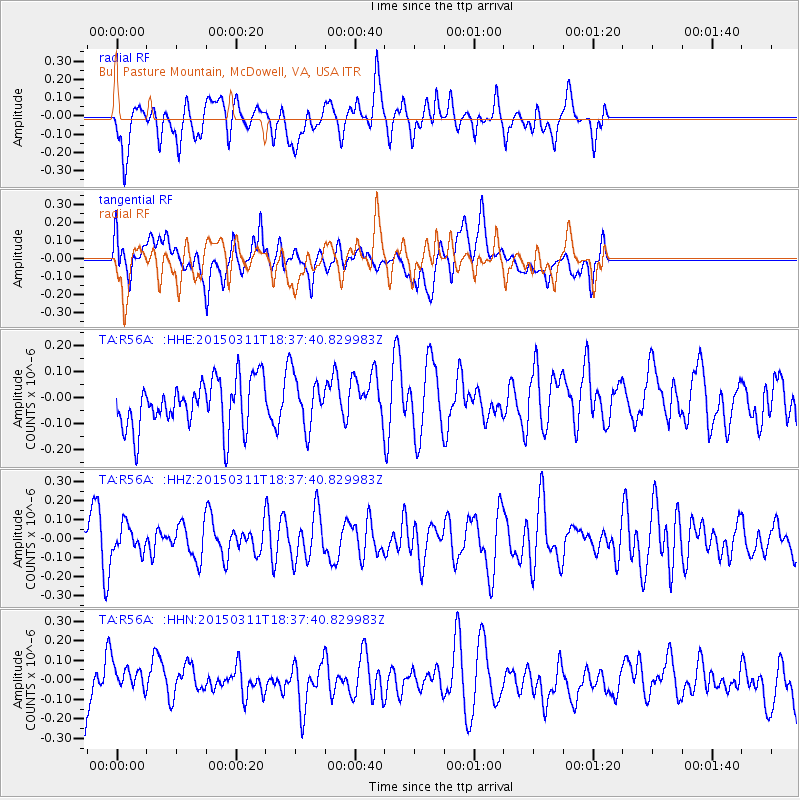
R56A Bull Pasture Mountain, McDowell, VA, USA - Earthquake Result Viewer
*The percent match for this event was below the threshold and hence no stack was calculated.
| Earthquake location: |
Hokkaido, Japan Region |
| Earthquake latitude/longitude: |
43.2/145.3 |
| Earthquake time(UTC): |
2015/03/11 (070) 18:25:24 GMT |
| Earthquake Depth: |
70 km |
| Earthquake Magnitude: |
3.7 mb |
| Earthquake Catalog/Contributor: |
ISC/ISC |
|
| Network: |
TA USArray Transportable Network (new EarthScope stations) |
| Station: |
R56A Bull Pasture Mountain, McDowell, VA, USA |
| Lat/Lon: |
38.41 N/79.40 W |
| Elevation: |
902 m |
|
| Distance: |
89.2 deg |
| Az: |
33.576 deg |
| Baz: |
329.046 deg |
| Ray Param: |
$rayparam |
*The percent match for this event was below the threshold and hence was not used in the summary stack. |
|
| Radial Match: |
48.96677 % |
| Radial Bump: |
400 |
| Transverse Match: |
47.952343 % |
| Transverse Bump: |
400 |
| SOD ConfigId: |
7019011 |
| Insert Time: |
2019-04-17 07:21:01.617 +0000 |
| GWidth: |
2.5 |
| Max Bumps: |
400 |
| Tol: |
0.001 |
|
Signal To Noise
| Channel | StoN | STA | LTA |
| TA:R56A: :HHZ:20150311T18:37:40.829983Z | 0.68343854 | 6.901739E-8 | 1.0098552E-7 |
| TA:R56A: :HHN:20150311T18:37:40.829983Z | 0.8417833 | 9.018462E-8 | 1.071352E-7 |
| TA:R56A: :HHE:20150311T18:37:40.829983Z | 1.0901768 | 1.0182624E-7 | 9.3403415E-8 |
| Arrivals |
| Ps | |
| PpPs | |
| PsPs/PpSs | |


