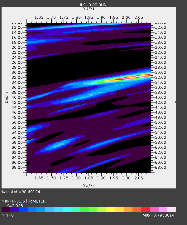
SUR Sutherland, South Africa - Earthquake Result Viewer
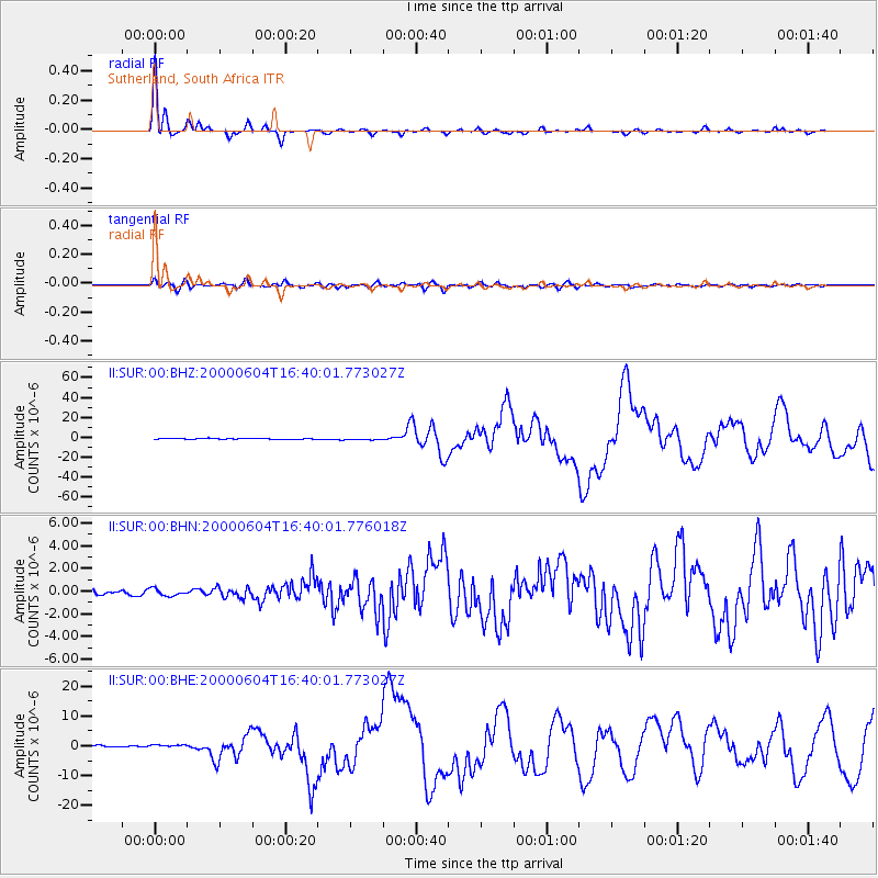
Earthquake location: Southern Sumatra, Indonesia
Earthquake latitude/longitude: -4.7/102.1
Earthquake time(UTC): 2000/06/04 (156) 16:28:26 GMT
Earthquake Depth: 33 km
Earthquake Magnitude: 6.8 MB, 8.0 MS, 7.9 MW, 7.7 MW
Earthquake Catalog/Contributor: WHDF/NEIC
Network: II Global Seismograph Network (GSN - IRIS/IDA)
Station: SUR Sutherland, South Africa
Lat/Lon: 32.38 S/20.81 E
Elevation: 1770 m
Distance: 80.1 deg
Az: 238.095 deg
Baz: 89.337 deg
Ray Param: 0.048445277
Estimated Moho Depth: 31.5 km
Estimated Crust Vp/Vs: 2.04
Assumed Crust Vp: 6.51 km/s
Estimated Crust Vs: 3.199 km/s
Estimated Crust Poisson's Ratio: 0.34
Radial Match: 98.69124 %
Radial Bump: 217
Transverse Match: 89.47535 %
Transverse Bump: 400
SOD ConfigId: 3744
Insert Time: 2010-03-01 23:02:14.144 +0000
GWidth: 2.5
Max Bumps: 400
Tol: 0.001

Signal To Noise

ChannelStoNSTALTA
II:SUR:00:BHN:20000604T16:40:01.776018Z1.09043633.0466012E-72.7939285E-7
II:SUR:00:BHE:20000604T16:40:01.773027Z2.27892025.622463E-72.4671613E-7
II:SUR:00:BHZ:20000604T16:40:01.773027Z2.08776028.6238276E-74.13066E-7
Arrivals
Ps5.1 SECOND
PpPs14 SECOND
PsPs/PpSs19 SECOND