You are here: Home > Network List > CI - Caltech Regional Seismic Network Stations List
> Station VCS Vincent Substation, Palmdale, CA, USA > Earthquake Result Viewer
VCS Vincent Substation, Palmdale, CA, USA - Earthquake Result Viewer
| Earthquake location: |
Alaska Peninsula |
| Earthquake latitude/longitude: |
54.7/-161.2 |
| Earthquake time(UTC): |
1999/10/13 (286) 01:33:40 GMT |
| Earthquake Depth: |
30 km |
| Earthquake Magnitude: |
6.0 MB, 6.2 MS, 6.5 MW, 6.0 ML |
| Earthquake Catalog/Contributor: |
WHDF/NEIC |
|
| Network: |
CI Caltech Regional Seismic Network |
| Station: |
VCS Vincent Substation, Palmdale, CA, USA |
| Lat/Lon: |
34.48 N/118.12 W |
| Elevation: |
991 m |
|
| Distance: |
36.0 deg |
| Az: |
106.177 deg |
| Baz: |
317.502 deg |
| Ray Param: |
0.076882005 |
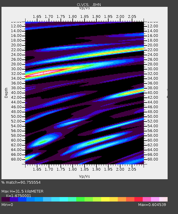
| Estimated Moho Depth: |
31.5 km |
| Estimated Crust Vp/Vs: |
1.68 |
| Assumed Crust Vp: |
6.1 km/s |
| Estimated Crust Vs: |
3.642 km/s |
| Estimated Crust Poisson's Ratio: |
0.22 |
|
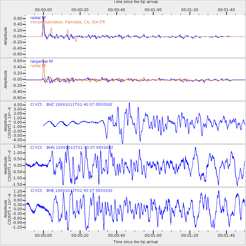
| Radial Match: |
90.755554 % |
| Radial Bump: |
351 |
| Transverse Match: |
70.11035 % |
| Transverse Bump: |
400 |
| SOD ConfigId: |
3787 |
| Insert Time: |
2010-02-25 21:07:47.753 +0000 |
| GWidth: |
2.5 |
| Max Bumps: |
400 |
| Tol: |
0.001 |
|
Signal To Noise
| Channel | StoN | STA | LTA |
| CI:VCS: :BHN:19991013T01:40:07.683009Z | 3.0818605 | 4.6111785E-7 | 1.4962319E-7 |
| CI:VCS: :BHE:19991013T01:40:07.683009Z | 1.2808323 | 2.915565E-7 | 2.276305E-7 |
| CI:VCS: :BHZ:19991013T01:40:07.683009Z | 3.5265965 | 1.1957372E-6 | 3.3906267E-7 |
| Arrivals |
| Ps | 3.7 SECOND |
| PpPs | 13 SECOND |
| PsPs/PpSs | 17 SECOND |


