You are here: Home > Network List > CI - Caltech Regional Seismic Network Stations List
> Station VCS Vincent Substation, Palmdale, CA, USA > Earthquake Result Viewer
VCS Vincent Substation, Palmdale, CA, USA - Earthquake Result Viewer

| Earthquake location: |
Southern Bolivia |
| Earthquake latitude/longitude: |
-20.9/-67.3 |
| Earthquake time(UTC): |
1999/09/15 (258) 03:01:24 GMT |
| Earthquake Depth: |
218 km |
| Earthquake Magnitude: |
6.0 MB, 6.4 MW, 6.4 MW |
| Earthquake Catalog/Contributor: |
WHDF/NEIC |
|
| Network: |
CI Caltech Regional Seismic Network |
| Station: |
VCS Vincent Substation, Palmdale, CA, USA |
| Lat/Lon: |
34.48 N/118.12 W |
| Elevation: |
991 m |
|
| Distance: |
73.3 deg |
| Az: |
318.029 deg |
| Baz: |
130.819 deg |
| Ray Param: |
0.052502234 |
| Estimated Moho Depth: |
30.75 km |
| Estimated Crust Vp/Vs: |
1.80 |
| Assumed Crust Vp: |
6.1 km/s |
| Estimated Crust Vs: |
3.389 km/s |
| Estimated Crust Poisson's Ratio: |
0.28 |
|
| Radial Match: |
89.22064 % |
| Radial Bump: |
400 |
| Transverse Match: |
76.15082 % |
| Transverse Bump: |
400 |
| SOD ConfigId: |
3787 |
| Insert Time: |
2010-02-25 21:07:49.262 +0000 |
| GWidth: |
2.5 |
| Max Bumps: |
400 |
| Tol: |
0.001 |
|
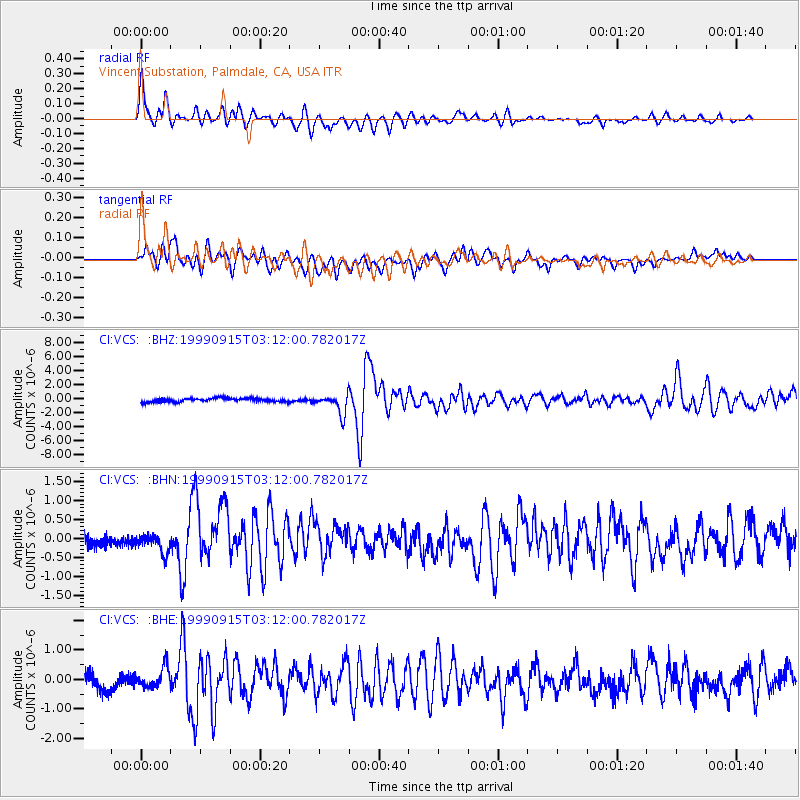
Signal To Noise
| Channel | StoN | STA | LTA |
| CI:VCS: :BHN:19990915T03:12:00.782017Z | 0.9483212 | 2.3102521E-7 | 2.4361495E-7 |
| CI:VCS: :BHE:19990915T03:12:00.782017Z | 1.3883002 | 3.4575132E-7 | 2.490465E-7 |
| CI:VCS: :BHZ:19990915T03:12:00.782017Z | 5.4756217 | 1.424012E-6 | 2.6006398E-7 |
| Arrivals |
| Ps | 4.2 SECOND |
| PpPs | 14 SECOND |
| PsPs/PpSs | 18 SECOND |


