You are here: Home > Network List > CI - Caltech Regional Seismic Network Stations List
> Station VCS Vincent Substation, Palmdale, CA, USA > Earthquake Result Viewer
VCS Vincent Substation, Palmdale, CA, USA - Earthquake Result Viewer
| Earthquake location: |
Ecuador |
| Earthquake latitude/longitude: |
-1.3/-77.5 |
| Earthquake time(UTC): |
1999/08/28 (240) 12:40:06 GMT |
| Earthquake Depth: |
196 km |
| Earthquake Magnitude: |
5.9 MB, 6.3 MW, 6.2 MW |
| Earthquake Catalog/Contributor: |
WHDF/NEIC |
|
| Network: |
CI Caltech Regional Seismic Network |
| Station: |
VCS Vincent Substation, Palmdale, CA, USA |
| Lat/Lon: |
34.48 N/118.12 W |
| Elevation: |
991 m |
|
| Distance: |
52.1 deg |
| Az: |
317.066 deg |
| Baz: |
124.474 deg |
| Ray Param: |
0.06630375 |
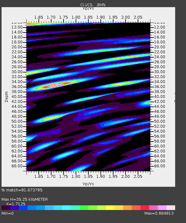
| Estimated Moho Depth: |
35.25 km |
| Estimated Crust Vp/Vs: |
1.71 |
| Assumed Crust Vp: |
6.1 km/s |
| Estimated Crust Vs: |
3.562 km/s |
| Estimated Crust Poisson's Ratio: |
0.24 |
|
| Radial Match: |
91.873795 % |
| Radial Bump: |
400 |
| Transverse Match: |
83.040886 % |
| Transverse Bump: |
400 |
| SOD ConfigId: |
3787 |
| Insert Time: |
2010-02-25 21:07:51.546 +0000 |
| GWidth: |
2.5 |
| Max Bumps: |
400 |
| Tol: |
0.001 |
|

Signal To Noise
| Channel | StoN | STA | LTA |
| CI:VCS: :BHN:19990828T12:48:25.179014Z | 5.259966 | 8.972611E-7 | 1.7058306E-7 |
| CI:VCS: :BHE:19990828T12:48:25.179014Z | 9.846877 | 1.2050494E-6 | 1.2237885E-7 |
| CI:VCS: :BHZ:19990828T12:48:25.179014Z | 29.775415 | 4.786192E-6 | 1.6074308E-7 |
| Arrivals |
| Ps | 4.3 SECOND |
| PpPs | 15 SECOND |
| PsPs/PpSs | 19 SECOND |


