You are here: Home > Network List > TA - USArray Transportable Network (new EarthScope stations) Stations List
> Station D51A Lot 18 Range III Mazenod Township, QC, CAN > Earthquake Result Viewer
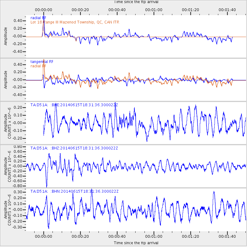
D51A Lot 18 Range III Mazenod Township, QC, CAN - Earthquake Result Viewer
*The percent match for this event was below the threshold and hence no stack was calculated.
| Earthquake location: |
Near East Coast Of Honshu, Japan |
| Earthquake latitude/longitude: |
36.6/141.8 |
| Earthquake time(UTC): |
2014/06/15 (166) 18:19:15 GMT |
| Earthquake Depth: |
23 km |
| Earthquake Magnitude: |
5.7 MB |
| Earthquake Catalog/Contributor: |
NEIC PDE/NEIC COMCAT |
|
| Network: |
TA USArray Transportable Network (new EarthScope stations) |
| Station: |
D51A Lot 18 Range III Mazenod Township, QC, CAN |
| Lat/Lon: |
47.09 N/79.37 W |
| Elevation: |
282 m |
|
| Distance: |
88.8 deg |
| Az: |
26.728 deg |
| Baz: |
328.035 deg |
| Ray Param: |
$rayparam |
*The percent match for this event was below the threshold and hence was not used in the summary stack. |
|
| Radial Match: |
53.491444 % |
| Radial Bump: |
400 |
| Transverse Match: |
44.159245 % |
| Transverse Bump: |
400 |
| SOD ConfigId: |
739768 |
| Insert Time: |
2014-06-29 19:02:28.617 +0000 |
| GWidth: |
2.5 |
| Max Bumps: |
400 |
| Tol: |
0.001 |
|
Signal To Noise
| Channel | StoN | STA | LTA |
| TA:D51A: :BHZ:20140615T18:31:36.300022Z | 4.222852 | 3.301988E-7 | 7.819331E-8 |
| TA:D51A: :BHN:20140615T18:31:36.300022Z | 1.7290627 | 1.4042546E-7 | 8.121479E-8 |
| TA:D51A: :BHE:20140615T18:31:36.300022Z | 0.99182546 | 8.119305E-8 | 8.186224E-8 |
| Arrivals |
| Ps | |
| PpPs | |
| PsPs/PpSs | |


