You are here: Home > Network List > TA - USArray Transportable Network (new EarthScope stations) Stations List
> Station H46A Fife Lake, MI, USA > Earthquake Result Viewer
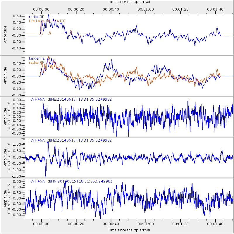
H46A Fife Lake, MI, USA - Earthquake Result Viewer
*The percent match for this event was below the threshold and hence no stack was calculated.
| Earthquake location: |
Near East Coast Of Honshu, Japan |
| Earthquake latitude/longitude: |
36.6/141.8 |
| Earthquake time(UTC): |
2014/06/15 (166) 18:19:15 GMT |
| Earthquake Depth: |
23 km |
| Earthquake Magnitude: |
5.7 MB |
| Earthquake Catalog/Contributor: |
NEIC PDE/NEIC COMCAT |
|
| Network: |
TA USArray Transportable Network (new EarthScope stations) |
| Station: |
H46A Fife Lake, MI, USA |
| Lat/Lon: |
44.54 N/85.20 W |
| Elevation: |
329 m |
|
| Distance: |
88.7 deg |
| Az: |
31.534 deg |
| Baz: |
323.969 deg |
| Ray Param: |
$rayparam |
*The percent match for this event was below the threshold and hence was not used in the summary stack. |
|
| Radial Match: |
58.466866 % |
| Radial Bump: |
400 |
| Transverse Match: |
62.282196 % |
| Transverse Bump: |
400 |
| SOD ConfigId: |
739768 |
| Insert Time: |
2014-06-29 19:05:48.135 +0000 |
| GWidth: |
2.5 |
| Max Bumps: |
400 |
| Tol: |
0.001 |
|
Signal To Noise
| Channel | StoN | STA | LTA |
| TA:H46A: :BHZ:20140615T18:31:35.524998Z | 4.1071377 | 6.3097644E-7 | 1.5362924E-7 |
| TA:H46A: :BHN:20140615T18:31:35.524998Z | 0.92400897 | 2.4470165E-7 | 2.6482604E-7 |
| TA:H46A: :BHE:20140615T18:31:35.524998Z | 1.0930817 | 2.5408343E-7 | 2.3244687E-7 |
| Arrivals |
| Ps | |
| PpPs | |
| PsPs/PpSs | |


