You are here: Home > Network List > TA - USArray Transportable Network (new EarthScope stations) Stations List
> Station Z41A Richland Creek Farm, El Dorado, AR, USA > Earthquake Result Viewer
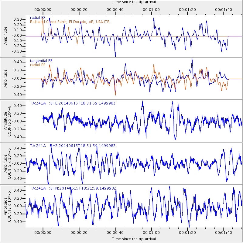
Z41A Richland Creek Farm, El Dorado, AR, USA - Earthquake Result Viewer
*The percent match for this event was below the threshold and hence no stack was calculated.
| Earthquake location: |
Near East Coast Of Honshu, Japan |
| Earthquake latitude/longitude: |
36.6/141.8 |
| Earthquake time(UTC): |
2014/06/15 (166) 18:19:15 GMT |
| Earthquake Depth: |
23 km |
| Earthquake Magnitude: |
5.7 MB |
| Earthquake Catalog/Contributor: |
NEIC PDE/NEIC COMCAT |
|
| Network: |
TA USArray Transportable Network (new EarthScope stations) |
| Station: |
Z41A Richland Creek Farm, El Dorado, AR, USA |
| Lat/Lon: |
33.26 N/92.80 W |
| Elevation: |
62 m |
|
| Distance: |
93.8 deg |
| Az: |
43.185 deg |
| Baz: |
318.936 deg |
| Ray Param: |
$rayparam |
*The percent match for this event was below the threshold and hence was not used in the summary stack. |
|
| Radial Match: |
57.99221 % |
| Radial Bump: |
400 |
| Transverse Match: |
66.94569 % |
| Transverse Bump: |
400 |
| SOD ConfigId: |
739768 |
| Insert Time: |
2014-06-29 19:12:41.902 +0000 |
| GWidth: |
2.5 |
| Max Bumps: |
400 |
| Tol: |
0.001 |
|
Signal To Noise
| Channel | StoN | STA | LTA |
| TA:Z41A: :BHZ:20140615T18:31:59.149998Z | 2.648575 | 2.7461704E-7 | 1.0368482E-7 |
| TA:Z41A: :BHN:20140615T18:31:59.149998Z | 1.0232673 | 1.3816899E-7 | 1.3502728E-7 |
| TA:Z41A: :BHE:20140615T18:31:59.149998Z | 1.088424 | 1.181627E-7 | 1.08563114E-7 |
| Arrivals |
| Ps | |
| PpPs | |
| PsPs/PpSs | |


