You are here: Home > Network List > US - United States National Seismic Network Stations List
> Station MNTX Cornudas Mountains, Texas, USA > Earthquake Result Viewer
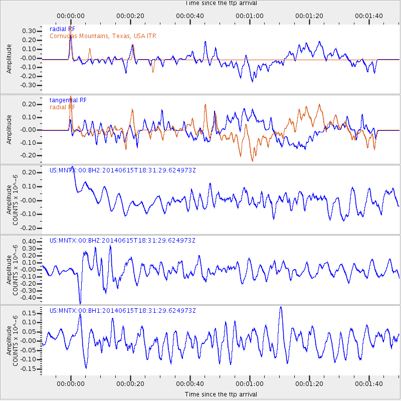
MNTX Cornudas Mountains, Texas, USA - Earthquake Result Viewer
*The percent match for this event was below the threshold and hence no stack was calculated.
| Earthquake location: |
Near East Coast Of Honshu, Japan |
| Earthquake latitude/longitude: |
36.6/141.8 |
| Earthquake time(UTC): |
2014/06/15 (166) 18:19:15 GMT |
| Earthquake Depth: |
23 km |
| Earthquake Magnitude: |
5.7 MB |
| Earthquake Catalog/Contributor: |
NEIC PDE/NEIC COMCAT |
|
| Network: |
US United States National Seismic Network |
| Station: |
MNTX Cornudas Mountains, Texas, USA |
| Lat/Lon: |
31.70 N/105.38 W |
| Elevation: |
404 m |
|
| Distance: |
87.4 deg |
| Az: |
51.847 deg |
| Baz: |
312.1 deg |
| Ray Param: |
$rayparam |
*The percent match for this event was below the threshold and hence was not used in the summary stack. |
|
| Radial Match: |
54.59548 % |
| Radial Bump: |
400 |
| Transverse Match: |
54.53413 % |
| Transverse Bump: |
400 |
| SOD ConfigId: |
739768 |
| Insert Time: |
2014-06-29 19:15:33.667 +0000 |
| GWidth: |
2.5 |
| Max Bumps: |
400 |
| Tol: |
0.001 |
|
Signal To Noise
| Channel | StoN | STA | LTA |
| US:MNTX:00:BHZ:20140615T18:31:29.624973Z | 2.1517174 | 1.8306348E-7 | 8.5077836E-8 |
| US:MNTX:00:BH1:20140615T18:31:29.624973Z | 1.452907 | 8.514358E-8 | 5.860223E-8 |
| US:MNTX:00:BH2:20140615T18:31:29.624973Z | 0.7490897 | 5.875169E-8 | 7.843078E-8 |
| Arrivals |
| Ps | |
| PpPs | |
| PsPs/PpSs | |


