You are here: Home > Network List > II - Global Seismograph Network (GSN - IRIS/IDA) Stations List
> Station SUR Sutherland, South Africa > Earthquake Result Viewer
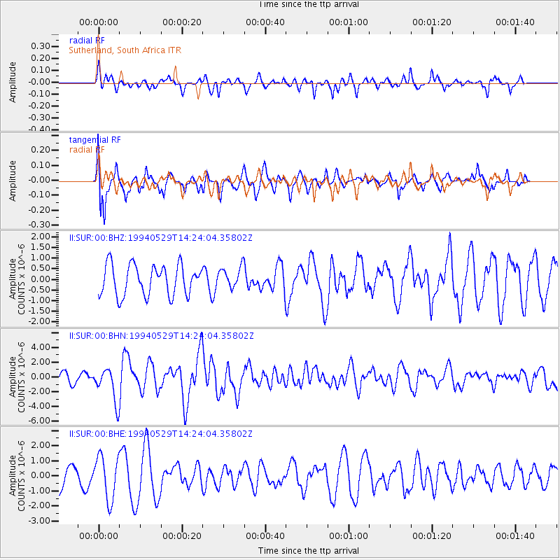
SUR Sutherland, South Africa - Earthquake Result Viewer
*The percent match for this event was below the threshold and hence no stack was calculated.
| Earthquake location: |
Myanmar |
| Earthquake latitude/longitude: |
20.5/94.2 |
| Earthquake time(UTC): |
1994/05/29 (149) 14:11:51 GMT |
| Earthquake Depth: |
42 km |
| Earthquake Magnitude: |
6.2 MB, 6.2 MS, 5.9 UNKNOWN, 6.5 MW |
| Earthquake Catalog/Contributor: |
WHDF/NEIC |
|
| Network: |
II Global Seismograph Network (GSN - IRIS/IDA) |
| Station: |
SUR Sutherland, South Africa |
| Lat/Lon: |
32.38 S/20.81 E |
| Elevation: |
1770 m |
|
| Distance: |
87.6 deg |
| Az: |
234.225 deg |
| Baz: |
63.979 deg |
| Ray Param: |
$rayparam |
*The percent match for this event was below the threshold and hence was not used in the summary stack. |
|
| Radial Match: |
54.342354 % |
| Radial Bump: |
348 |
| Transverse Match: |
67.11449 % |
| Transverse Bump: |
400 |
| SOD ConfigId: |
4480 |
| Insert Time: |
2010-03-01 23:03:24.182 +0000 |
| GWidth: |
2.5 |
| Max Bumps: |
400 |
| Tol: |
0.001 |
|
Signal To Noise
| Channel | StoN | STA | LTA |
| II:SUR:00:BHN:19940529T14:24:04.35802Z | 2.5880644 | 2.3527252E-6 | 9.0906747E-7 |
| II:SUR:00:BHE:19940529T14:24:04.35802Z | 2.1211462 | 1.4840704E-6 | 6.996549E-7 |
| II:SUR:00:BHZ:19940529T14:24:04.35802Z | 0.7141233 | 5.099462E-7 | 7.1408704E-7 |
| Arrivals |
| Ps | |
| PpPs | |
| PsPs/PpSs | |


