You are here: Home > Network List > II - Global Seismograph Network (GSN - IRIS/IDA) Stations List
> Station PALK Pallekele, Sri Lanka > Earthquake Result Viewer
PALK Pallekele, Sri Lanka - Earthquake Result Viewer
| Earthquake location: |
Vanuatu Islands |
| Earthquake latitude/longitude: |
-14.9/167.2 |
| Earthquake time(UTC): |
2001/01/09 (009) 16:49:28 GMT |
| Earthquake Depth: |
103 km |
| Earthquake Magnitude: |
6.3 MB, 6.6 MS, 7.6 ME, 7.0 MW |
| Earthquake Catalog/Contributor: |
WHDF/NEIC |
|
| Network: |
II Global Seismograph Network (GSN - IRIS/IDA) |
| Station: |
PALK Pallekele, Sri Lanka |
| Lat/Lon: |
7.27 N/80.70 E |
| Elevation: |
460 m |
|
| Distance: |
88.5 deg |
| Az: |
277.89 deg |
| Baz: |
105.162 deg |
| Ray Param: |
0.042355496 |
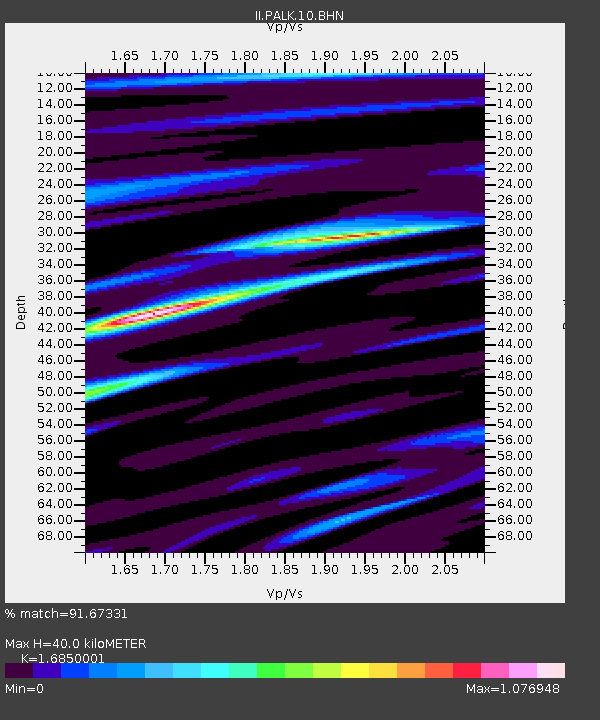
| Estimated Moho Depth: |
40.0 km |
| Estimated Crust Vp/Vs: |
1.69 |
| Assumed Crust Vp: |
6.545 km/s |
| Estimated Crust Vs: |
3.884 km/s |
| Estimated Crust Poisson's Ratio: |
0.23 |
|
| Radial Match: |
91.67331 % |
| Radial Bump: |
357 |
| Transverse Match: |
84.03046 % |
| Transverse Bump: |
400 |
| SOD ConfigId: |
3744 |
| Insert Time: |
2010-03-01 23:03:41.805 +0000 |
| GWidth: |
2.5 |
| Max Bumps: |
400 |
| Tol: |
0.001 |
|
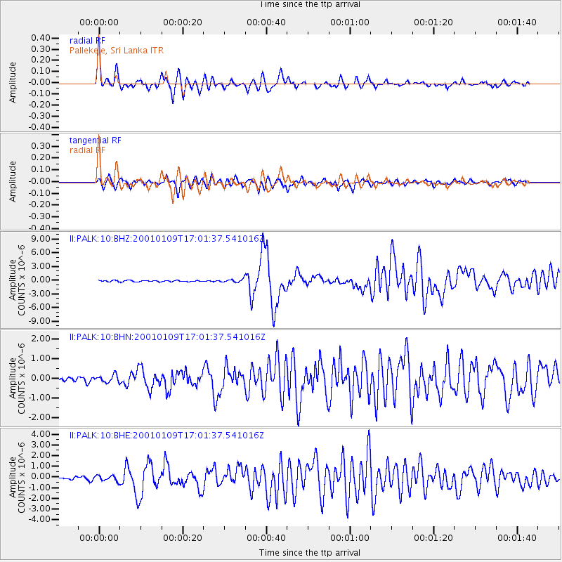
Signal To Noise
| Channel | StoN | STA | LTA |
| II:PALK:10:BHN:20010109T17:01:37.541016Z | 1.6050272 | 1.888299E-7 | 1.1764904E-7 |
| II:PALK:10:BHE:20010109T17:01:37.541016Z | 1.9120142 | 2.5667183E-7 | 1.3424159E-7 |
| II:PALK:10:BHZ:20010109T17:01:37.541016Z | 2.6175032 | 3.6359714E-7 | 1.3890991E-7 |
| Arrivals |
| Ps | 4.3 SECOND |
| PpPs | 16 SECOND |
| PsPs/PpSs | 20 SECOND |


