You are here: Home > Network List > II - Global Seismograph Network (GSN - IRIS/IDA) Stations List
> Station PALK Pallekele, Sri Lanka > Earthquake Result Viewer
PALK Pallekele, Sri Lanka - Earthquake Result Viewer
| Earthquake location: |
Northern Molucca Sea |
| Earthquake latitude/longitude: |
1.3/126.2 |
| Earthquake time(UTC): |
2001/02/24 (055) 07:23:48 GMT |
| Earthquake Depth: |
35 km |
| Earthquake Magnitude: |
6.6 MB, 7.0 MS, 7.1 MW, 7.1 ME |
| Earthquake Catalog/Contributor: |
WHDF/NEIC |
|
| Network: |
II Global Seismograph Network (GSN - IRIS/IDA) |
| Station: |
PALK Pallekele, Sri Lanka |
| Lat/Lon: |
7.27 N/80.70 E |
| Elevation: |
460 m |
|
| Distance: |
45.8 deg |
| Az: |
278.863 deg |
| Baz: |
95.299 deg |
| Ray Param: |
0.07098047 |
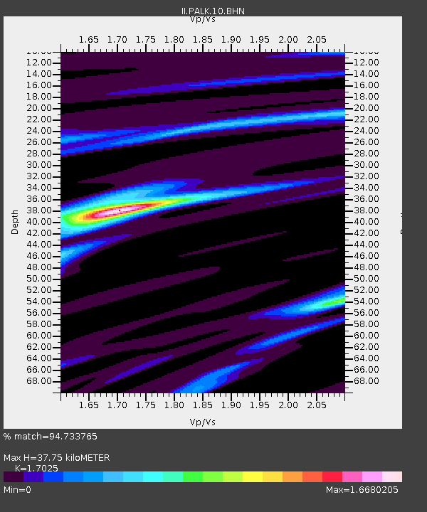
| Estimated Moho Depth: |
37.75 km |
| Estimated Crust Vp/Vs: |
1.70 |
| Assumed Crust Vp: |
6.545 km/s |
| Estimated Crust Vs: |
3.845 km/s |
| Estimated Crust Poisson's Ratio: |
0.24 |
|
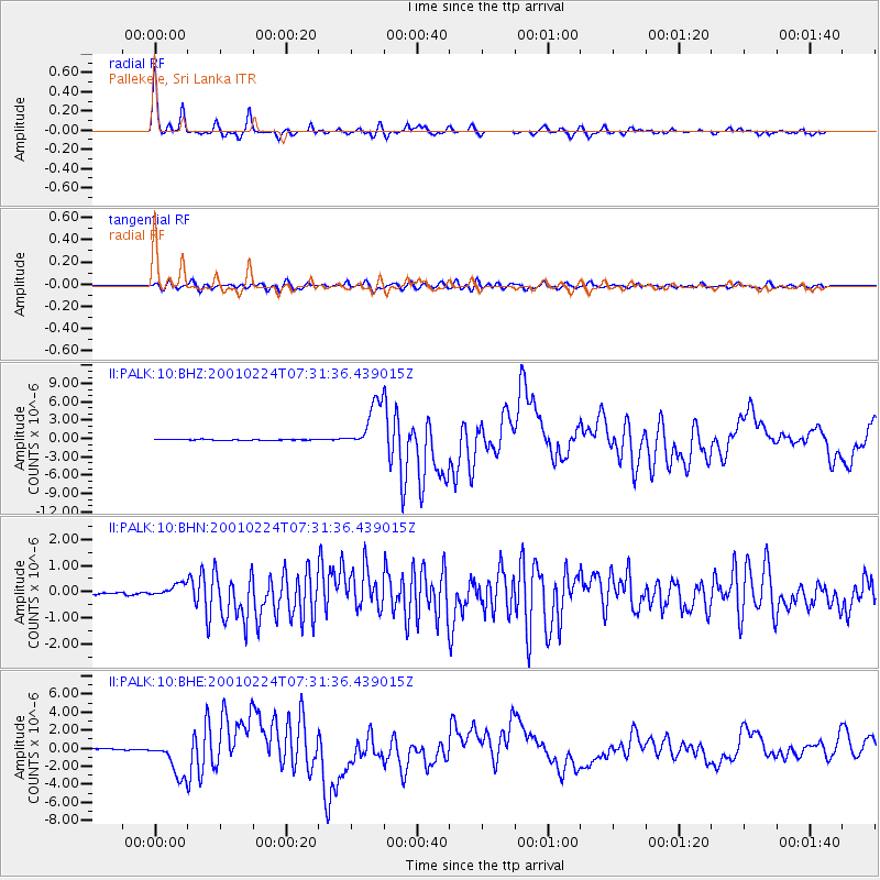
| Radial Match: |
94.733765 % |
| Radial Bump: |
277 |
| Transverse Match: |
75.47409 % |
| Transverse Bump: |
400 |
| SOD ConfigId: |
3744 |
| Insert Time: |
2010-03-01 23:03:46.890 +0000 |
| GWidth: |
2.5 |
| Max Bumps: |
400 |
| Tol: |
0.001 |
|
Signal To Noise
| Channel | StoN | STA | LTA |
| II:PALK:10:BHN:20010224T07:31:36.439015Z | 6.5242686 | 2.5479022E-7 | 3.9052686E-8 |
| II:PALK:10:BHE:20010224T07:31:36.439015Z | 39.15705 | 2.0474886E-6 | 5.2289142E-8 |
| II:PALK:10:BHZ:20010224T07:31:36.439015Z | 54.258717 | 3.8954067E-6 | 7.1793195E-8 |
| Arrivals |
| Ps | 4.3 SECOND |
| PpPs | 15 SECOND |
| PsPs/PpSs | 19 SECOND |


