You are here: Home > Network List > TA - USArray Transportable Network (new EarthScope stations) Stations List
> Station P57A Homestead Farm, Martinsburg, WV, USA > Earthquake Result Viewer
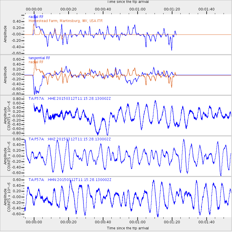
P57A Homestead Farm, Martinsburg, WV, USA - Earthquake Result Viewer
*The percent match for this event was below the threshold and hence no stack was calculated.
| Earthquake location: |
Near East Coast Of Honshu, Japan |
| Earthquake latitude/longitude: |
37.3/141.6 |
| Earthquake time(UTC): |
2015/03/12 (071) 11:02:40 GMT |
| Earthquake Depth: |
44 km |
| Earthquake Magnitude: |
5.0 MW |
| Earthquake Catalog/Contributor: |
ISC/ISC |
|
| Network: |
TA USArray Transportable Network (new EarthScope stations) |
| Station: |
P57A Homestead Farm, Martinsburg, WV, USA |
| Lat/Lon: |
39.48 N/78.01 W |
| Elevation: |
191 m |
|
| Distance: |
95.3 deg |
| Az: |
29.706 deg |
| Baz: |
329.313 deg |
| Ray Param: |
$rayparam |
*The percent match for this event was below the threshold and hence was not used in the summary stack. |
|
| Radial Match: |
64.73799 % |
| Radial Bump: |
400 |
| Transverse Match: |
41.765648 % |
| Transverse Bump: |
400 |
| SOD ConfigId: |
7019011 |
| Insert Time: |
2019-04-17 07:54:05.344 +0000 |
| GWidth: |
2.5 |
| Max Bumps: |
400 |
| Tol: |
0.001 |
|
Signal To Noise
| Channel | StoN | STA | LTA |
| TA:P57A: :HHZ:20150312T11:15:28.130002Z | 0.35578883 | 8.9216535E-8 | 2.5075698E-7 |
| TA:P57A: :HHN:20150312T11:15:28.130002Z | 0.67356515 | 1.4827849E-7 | 2.2013977E-7 |
| TA:P57A: :HHE:20150312T11:15:28.130002Z | 1.4595292 | 2.5587985E-7 | 1.7531671E-7 |
| Arrivals |
| Ps | |
| PpPs | |
| PsPs/PpSs | |


