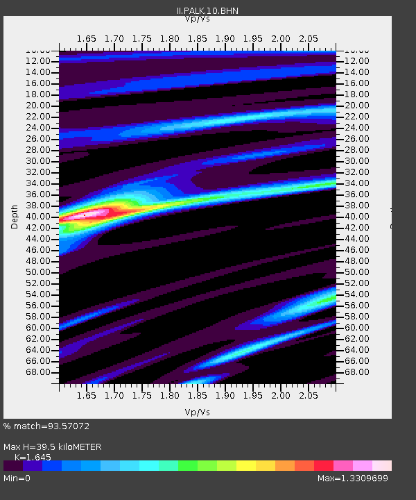
PALK Pallekele, Sri Lanka - Earthquake Result Viewer
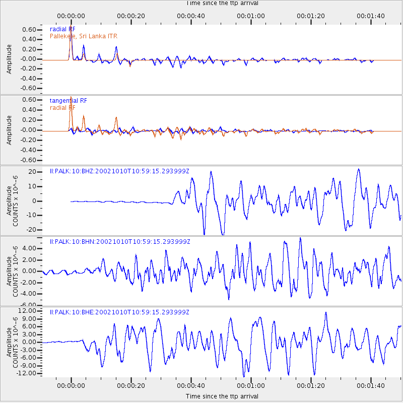
Earthquake location: Irian Jaya Region, Indonesia
Earthquake latitude/longitude: -1.8/134.3
Earthquake time(UTC): 2002/10/10 (283) 10:50:20 GMT
Earthquake Depth: 10 km
Earthquake Magnitude: 6.5 MB, 7.7 MS, 7.6 MW, 7.4 MW
Earthquake Catalog/Contributor: WHDF/NEIC
Network: II Global Seismograph Network (GSN - IRIS/IDA)
Station: PALK Pallekele, Sri Lanka
Lat/Lon: 7.27 N/80.70 E
Elevation: 460 m
Distance: 54.2 deg
Az: 280.198 deg
Baz: 97.423 deg
Ray Param: 0.06558415
Estimated Moho Depth: 39.5 km
Estimated Crust Vp/Vs: 1.64
Assumed Crust Vp: 6.545 km/s
Estimated Crust Vs: 3.979 km/s
Estimated Crust Poisson's Ratio: 0.21
Radial Match: 93.57072 %
Radial Bump: 247
Transverse Match: 79.945015 %
Transverse Bump: 400
SOD ConfigId: 4714
Insert Time: 2010-03-01 23:04:18.254 +0000
GWidth: 2.5
Max Bumps: 400
Tol: 0.001

Signal To Noise

ChannelStoNSTALTA
II:PALK:10:BHN:20021010T10:59:15.293999Z1.34826332.346401E-71.7403137E-7
II:PALK:10:BHE:20021010T10:59:15.293999Z4.03522837.119153E-71.7642502E-7
II:PALK:10:BHZ:20021010T10:59:15.293999Z5.1395431.2685132E-62.468144E-7
Arrivals
Ps4.1 SECOND
PpPs15 SECOND
PsPs/PpSs19 SECOND