You are here: Home > Network List > II - Global Seismograph Network (GSN - IRIS/IDA) Stations List
> Station PALK Pallekele, Sri Lanka > Earthquake Result Viewer
PALK Pallekele, Sri Lanka - Earthquake Result Viewer
| Earthquake location: |
Qinghai, China |
| Earthquake latitude/longitude: |
37.5/96.5 |
| Earthquake time(UTC): |
2003/04/17 (107) 00:48:38 GMT |
| Earthquake Depth: |
14 km |
| Earthquake Magnitude: |
6.2 MB, 6.3 MS, 6.4 MW, 6.2 MW |
| Earthquake Catalog/Contributor: |
WHDF/NEIC |
|
| Network: |
II Global Seismograph Network (GSN - IRIS/IDA) |
| Station: |
PALK Pallekele, Sri Lanka |
| Lat/Lon: |
7.27 N/80.70 E |
| Elevation: |
460 m |
|
| Distance: |
33.4 deg |
| Az: |
209.373 deg |
| Baz: |
23.146 deg |
| Ray Param: |
0.07823767 |
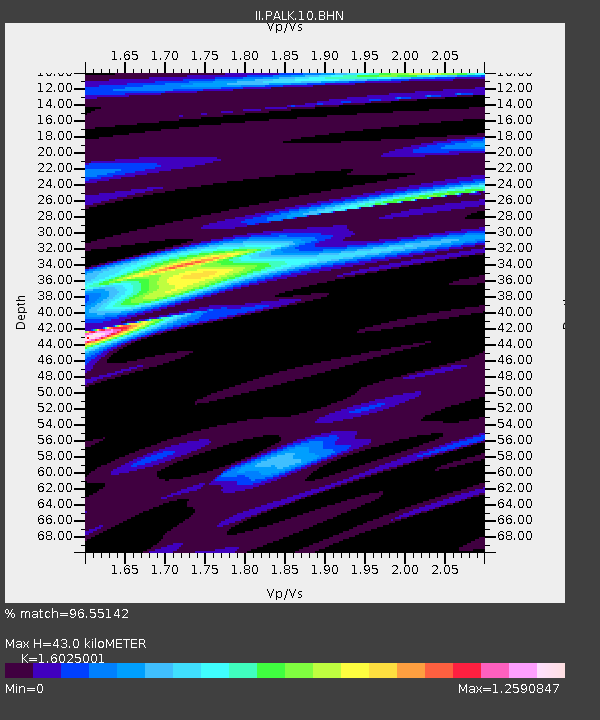
| Estimated Moho Depth: |
43.0 km |
| Estimated Crust Vp/Vs: |
1.60 |
| Assumed Crust Vp: |
6.545 km/s |
| Estimated Crust Vs: |
4.084 km/s |
| Estimated Crust Poisson's Ratio: |
0.18 |
|
| Radial Match: |
96.55142 % |
| Radial Bump: |
271 |
| Transverse Match: |
87.92077 % |
| Transverse Bump: |
400 |
| SOD ConfigId: |
4714 |
| Insert Time: |
2010-03-01 23:04:34.119 +0000 |
| GWidth: |
2.5 |
| Max Bumps: |
400 |
| Tol: |
0.001 |
|
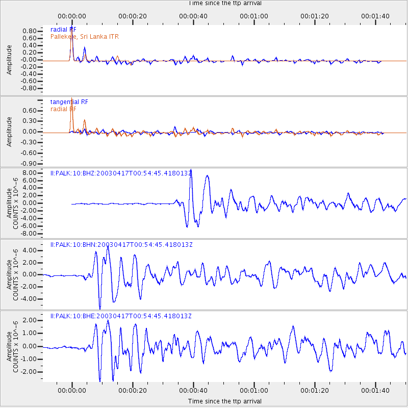
Signal To Noise
| Channel | StoN | STA | LTA |
| II:PALK:10:BHN:20030417T00:54:45.418013Z | 3.031846 | 2.2511061E-7 | 7.4248696E-8 |
| II:PALK:10:BHE:20030417T00:54:45.418013Z | 1.5093238 | 1.0288801E-7 | 6.8168276E-8 |
| II:PALK:10:BHZ:20030417T00:54:45.418013Z | 3.422977 | 3.034702E-7 | 8.86568E-8 |
| Arrivals |
| Ps | 4.3 SECOND |
| PpPs | 16 SECOND |
| PsPs/PpSs | 20 SECOND |


