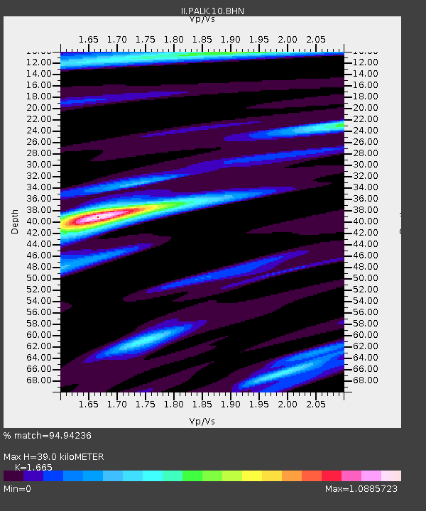
PALK Pallekele, Sri Lanka - Earthquake Result Viewer
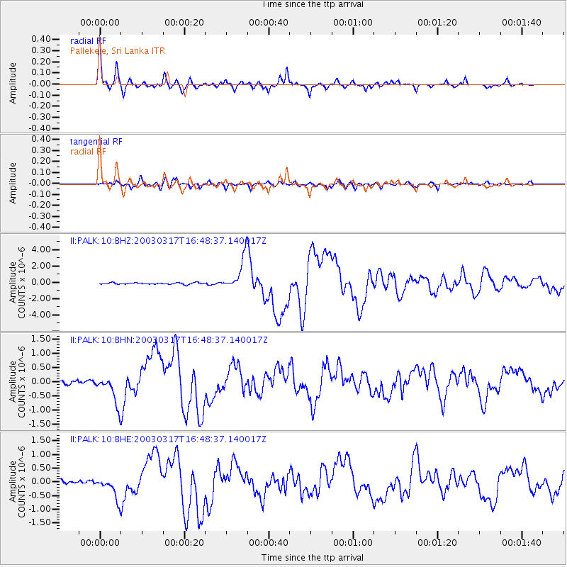
Earthquake location: Rat Islands, Aleutian Islands
Earthquake latitude/longitude: 51.3/178.0
Earthquake time(UTC): 2003/03/17 (076) 16:36:17 GMT
Earthquake Depth: 33 km
Earthquake Magnitude: 5.9 MB, 6.7 MS, 7.0 MW, 7.0 MW
Earthquake Catalog/Contributor: WHDF/NEIC
Network: II Global Seismograph Network (GSN - IRIS/IDA)
Station: PALK Pallekele, Sri Lanka
Lat/Lon: 7.27 N/80.70 E
Elevation: 460 m
Distance: 88.9 deg
Az: 280.183 deg
Baz: 38.553 deg
Ray Param: 0.042189784
Estimated Moho Depth: 39.0 km
Estimated Crust Vp/Vs: 1.66
Assumed Crust Vp: 6.545 km/s
Estimated Crust Vs: 3.931 km/s
Estimated Crust Poisson's Ratio: 0.22
Radial Match: 94.94236 %
Radial Bump: 378
Transverse Match: 85.8911 %
Transverse Bump: 400
SOD ConfigId: 4714
Insert Time: 2010-03-01 23:04:39.574 +0000
GWidth: 2.5
Max Bumps: 400
Tol: 0.001

Signal To Noise

ChannelStoNSTALTA
II:PALK:10:BHN:20030317T16:48:37.140017Z6.86196235.398314E-77.867012E-8
II:PALK:10:BHE:20030317T16:48:37.140017Z6.4418474.2279234E-76.563216E-8
II:PALK:10:BHZ:20030317T16:48:37.140017Z22.0889052.0667756E-69.356623E-8
Arrivals
Ps4.1 SECOND
PpPs16 SECOND
PsPs/PpSs20 SECOND