You are here: Home > Network List > TA - USArray Transportable Network (new EarthScope stations) Stations List
> Station D51A Lot 18 Range III Mazenod Township, QC, CAN > Earthquake Result Viewer
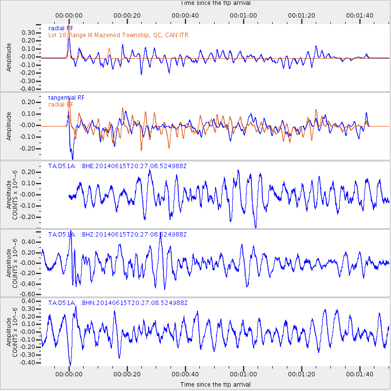
D51A Lot 18 Range III Mazenod Township, QC, CAN - Earthquake Result Viewer
*The percent match for this event was below the threshold and hence no stack was calculated.
| Earthquake location: |
Near East Coast Of Honshu, Japan |
| Earthquake latitude/longitude: |
37.1/141.1 |
| Earthquake time(UTC): |
2014/06/15 (166) 20:14:50 GMT |
| Earthquake Depth: |
40 km |
| Earthquake Magnitude: |
5.6 MB |
| Earthquake Catalog/Contributor: |
NEIC PDE/NEIC COMCAT |
|
| Network: |
TA USArray Transportable Network (new EarthScope stations) |
| Station: |
D51A Lot 18 Range III Mazenod Township, QC, CAN |
| Lat/Lon: |
47.09 N/79.37 W |
| Elevation: |
282 m |
|
| Distance: |
88.7 deg |
| Az: |
26.324 deg |
| Baz: |
328.749 deg |
| Ray Param: |
$rayparam |
*The percent match for this event was below the threshold and hence was not used in the summary stack. |
|
| Radial Match: |
62.788822 % |
| Radial Bump: |
400 |
| Transverse Match: |
48.875916 % |
| Transverse Bump: |
400 |
| SOD ConfigId: |
739768 |
| Insert Time: |
2014-06-29 20:57:44.951 +0000 |
| GWidth: |
2.5 |
| Max Bumps: |
400 |
| Tol: |
0.001 |
|
Signal To Noise
| Channel | StoN | STA | LTA |
| TA:D51A: :BHZ:20140615T20:27:08.524988Z | 2.5883732 | 3.0295257E-7 | 1.17043626E-7 |
| TA:D51A: :BHN:20140615T20:27:08.524988Z | 2.1622794 | 2.2002305E-7 | 1.0175515E-7 |
| TA:D51A: :BHE:20140615T20:27:08.524988Z | 1.2218012 | 7.937216E-8 | 6.496324E-8 |
| Arrivals |
| Ps | |
| PpPs | |
| PsPs/PpSs | |


