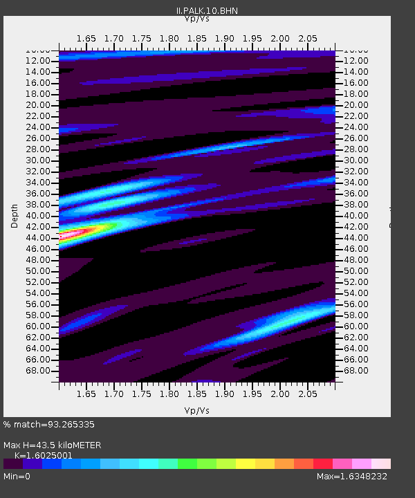
PALK Pallekele, Sri Lanka - Earthquake Result Viewer
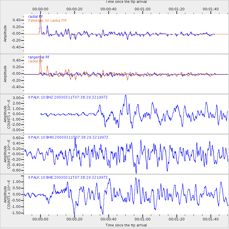
Earthquake location: New Ireland Region, P.N.G.
Earthquake latitude/longitude: -4.7/153.2
Earthquake time(UTC): 2003/03/11 (070) 07:27:32 GMT
Earthquake Depth: 40 km
Earthquake Magnitude: 6.0 MB, 6.8 MS, 6.8 MW, 6.6 MW
Earthquake Catalog/Contributor: WHDF/NEIC
Network: II Global Seismograph Network (GSN - IRIS/IDA)
Station: PALK Pallekele, Sri Lanka
Lat/Lon: 7.27 N/80.70 E
Elevation: 460 m
Distance: 73.4 deg
Az: 278.98 deg
Baz: 97.09 deg
Ray Param: 0.052994795
Estimated Moho Depth: 43.5 km
Estimated Crust Vp/Vs: 1.60
Assumed Crust Vp: 6.545 km/s
Estimated Crust Vs: 4.084 km/s
Estimated Crust Poisson's Ratio: 0.18
Radial Match: 93.265335 %
Radial Bump: 400
Transverse Match: 67.54459 %
Transverse Bump: 400
SOD ConfigId: 4714
Insert Time: 2010-03-01 23:04:43.112 +0000
GWidth: 2.5
Max Bumps: 400
Tol: 0.001

Signal To Noise

ChannelStoNSTALTA
II:PALK:10:BHN:20030311T07:38:29.321997Z1.09952841.11181855E-71.0111776E-7
II:PALK:10:BHE:20030311T07:38:29.321997Z2.24008942.1875802E-79.7655935E-8
II:PALK:10:BHZ:20030311T07:38:29.321997Z4.55030735.532963E-71.2159536E-7
Arrivals
Ps4.2 SECOND
PpPs17 SECOND
PsPs/PpSs21 SECOND