You are here: Home > Network List > TA - USArray Transportable Network (new EarthScope stations) Stations List
> Station R11A Troy Canyon, Currant, NV, USA > Earthquake Result Viewer
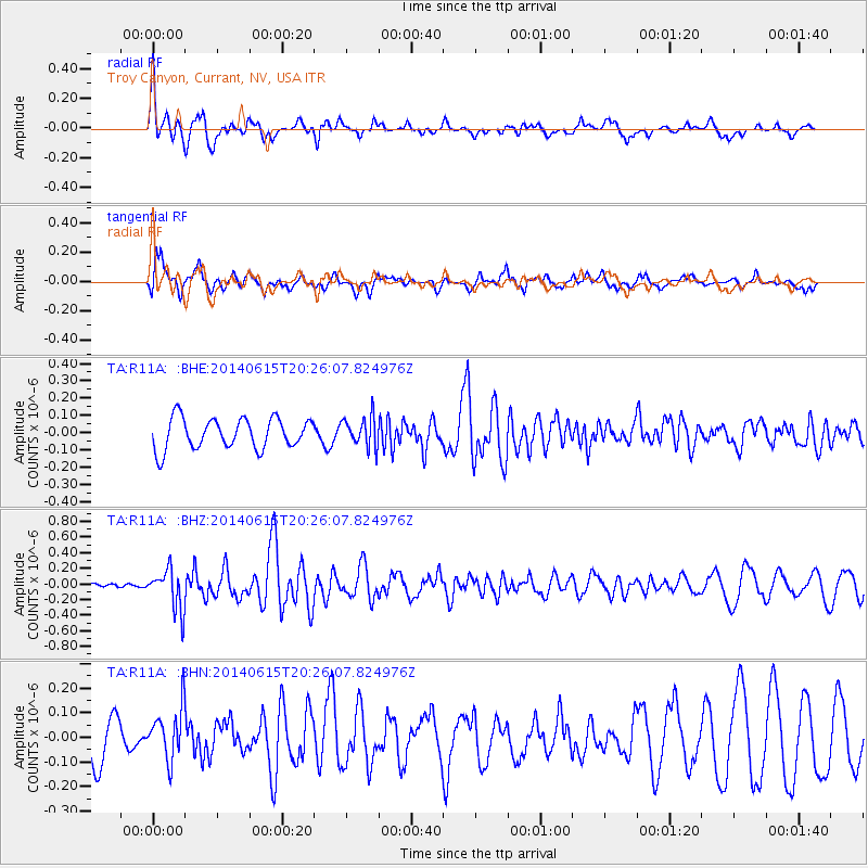
R11A Troy Canyon, Currant, NV, USA - Earthquake Result Viewer
*The percent match for this event was below the threshold and hence no stack was calculated.
| Earthquake location: |
Near East Coast Of Honshu, Japan |
| Earthquake latitude/longitude: |
37.1/141.1 |
| Earthquake time(UTC): |
2014/06/15 (166) 20:14:50 GMT |
| Earthquake Depth: |
40 km |
| Earthquake Magnitude: |
5.6 MB |
| Earthquake Catalog/Contributor: |
NEIC PDE/NEIC COMCAT |
|
| Network: |
TA USArray Transportable Network (new EarthScope stations) |
| Station: |
R11A Troy Canyon, Currant, NV, USA |
| Lat/Lon: |
38.35 N/115.59 W |
| Elevation: |
1756 m |
|
| Distance: |
76.9 deg |
| Az: |
51.76 deg |
| Baz: |
307.008 deg |
| Ray Param: |
$rayparam |
*The percent match for this event was below the threshold and hence was not used in the summary stack. |
|
| Radial Match: |
79.300385 % |
| Radial Bump: |
400 |
| Transverse Match: |
58.814194 % |
| Transverse Bump: |
390 |
| SOD ConfigId: |
739768 |
| Insert Time: |
2014-06-29 21:05:00.697 +0000 |
| GWidth: |
2.5 |
| Max Bumps: |
400 |
| Tol: |
0.001 |
|
Signal To Noise
| Channel | StoN | STA | LTA |
| TA:R11A: :BHZ:20140615T20:26:07.824976Z | 4.9570107 | 2.5998366E-7 | 5.244767E-8 |
| TA:R11A: :BHN:20140615T20:26:07.824976Z | 1.5482802 | 1.10448575E-7 | 7.1336295E-8 |
| TA:R11A: :BHE:20140615T20:26:07.824976Z | 0.9996428 | 8.824902E-8 | 8.828055E-8 |
| Arrivals |
| Ps | |
| PpPs | |
| PsPs/PpSs | |


