You are here: Home > Network List > II - Global Seismograph Network (GSN - IRIS/IDA) Stations List
> Station PALK Pallekele, Sri Lanka > Earthquake Result Viewer
PALK Pallekele, Sri Lanka - Earthquake Result Viewer
| Earthquake location: |
Hokkaido, Japan Region |
| Earthquake latitude/longitude: |
43.0/145.1 |
| Earthquake time(UTC): |
2004/11/28 (333) 18:32:14 GMT |
| Earthquake Depth: |
39 km |
| Earthquake Magnitude: |
6.4 MB, 6.7 MS, 7.0 MW, 7.0 MW |
| Earthquake Catalog/Contributor: |
WHDF/NEIC |
|
| Network: |
II Global Seismograph Network (GSN - IRIS/IDA) |
| Station: |
PALK Pallekele, Sri Lanka |
| Lat/Lon: |
7.27 N/80.70 E |
| Elevation: |
460 m |
|
| Distance: |
66.4 deg |
| Az: |
257.468 deg |
| Baz: |
46.205 deg |
| Ray Param: |
0.05754569 |
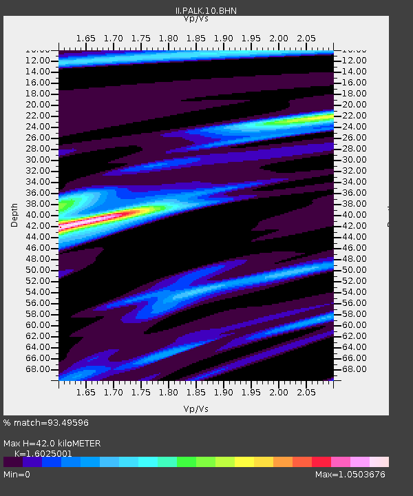
| Estimated Moho Depth: |
42.0 km |
| Estimated Crust Vp/Vs: |
1.60 |
| Assumed Crust Vp: |
6.545 km/s |
| Estimated Crust Vs: |
4.084 km/s |
| Estimated Crust Poisson's Ratio: |
0.18 |
|
| Radial Match: |
93.49596 % |
| Radial Bump: |
258 |
| Transverse Match: |
85.78717 % |
| Transverse Bump: |
364 |
| SOD ConfigId: |
2459 |
| Insert Time: |
2010-03-01 23:05:05.713 +0000 |
| GWidth: |
2.5 |
| Max Bumps: |
400 |
| Tol: |
0.001 |
|
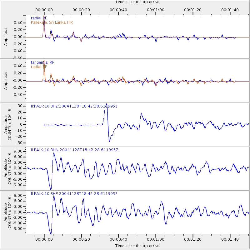
Signal To Noise
| Channel | StoN | STA | LTA |
| II:PALK:10:BHN:20041128T18:42:28.611995Z | 26.619678 | 5.4114444E-6 | 2.0328736E-7 |
| II:PALK:10:BHE:20041128T18:42:28.611995Z | 17.954218 | 5.718394E-6 | 3.1849862E-7 |
| II:PALK:10:BHZ:20041128T18:42:28.611995Z | 48.751034 | 1.7078382E-5 | 3.5031834E-7 |
| Arrivals |
| Ps | 4.1 SECOND |
| PpPs | 16 SECOND |
| PsPs/PpSs | 20 SECOND |


