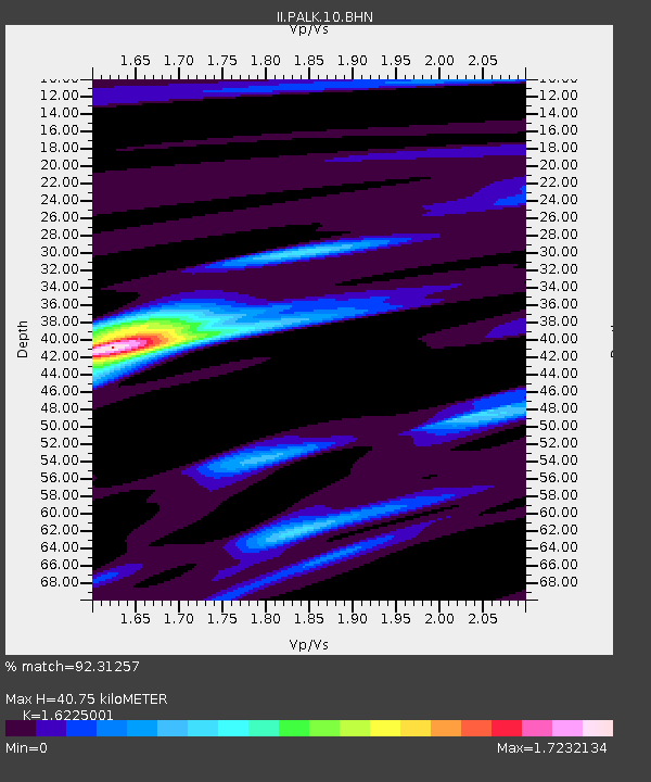
PALK Pallekele, Sri Lanka - Earthquake Result Viewer
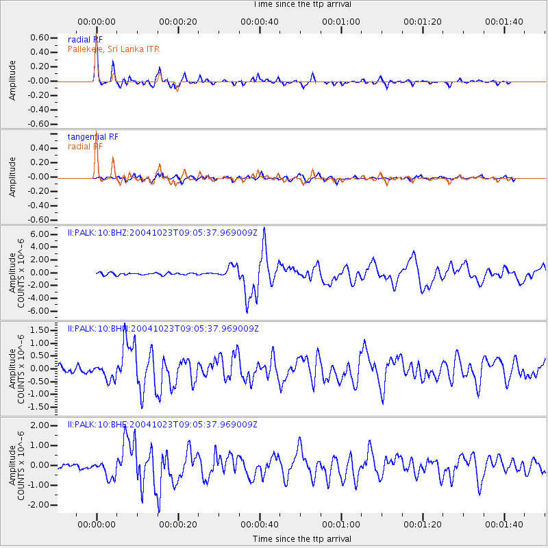
Earthquake location: Near West Coast Of Honshu, Japan
Earthquake latitude/longitude: 37.2/138.8
Earthquake time(UTC): 2004/10/23 (297) 08:56:00 GMT
Earthquake Depth: 16 km
Earthquake Magnitude: 6.4 MB, 6.3 MS, 6.6 MW, 6.4 MW
Earthquake Catalog/Contributor: WHDF/NEIC
Network: II Global Seismograph Network (GSN - IRIS/IDA)
Station: PALK Pallekele, Sri Lanka
Lat/Lon: 7.27 N/80.70 E
Elevation: 460 m
Distance: 60.4 deg
Az: 255.637 deg
Baz: 51.21 deg
Ray Param: 0.06156743
Estimated Moho Depth: 40.75 km
Estimated Crust Vp/Vs: 1.62
Assumed Crust Vp: 6.545 km/s
Estimated Crust Vs: 4.034 km/s
Estimated Crust Poisson's Ratio: 0.19
Radial Match: 92.31257 %
Radial Bump: 318
Transverse Match: 84.225136 %
Transverse Bump: 400
SOD ConfigId: 2459
Insert Time: 2010-03-01 23:05:07.174 +0000
GWidth: 2.5
Max Bumps: 400
Tol: 0.001

Signal To Noise

ChannelStoNSTALTA
II:PALK:10:BHN:20041023T09:05:37.969009Z2.73429682.9557324E-71.0809845E-7
II:PALK:10:BHE:20041023T09:05:37.969009Z5.01598074.4518586E-78.87535E-8
II:PALK:10:BHZ:20041023T09:05:37.969009Z5.6178319.4252493E-71.677738E-7
Arrivals
Ps4.1 SECOND
PpPs15 SECOND
PsPs/PpSs20 SECOND