You are here: Home > Network List > US - United States National Seismic Network Stations List
> Station MSO Missoula, Montana, USA > Earthquake Result Viewer
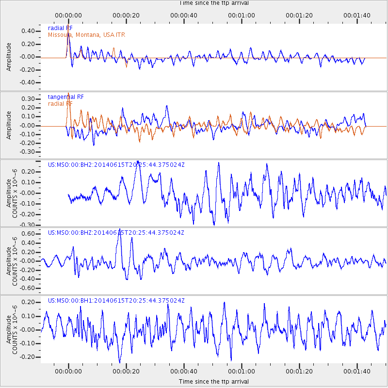
MSO Missoula, Montana, USA - Earthquake Result Viewer
*The percent match for this event was below the threshold and hence no stack was calculated.
| Earthquake location: |
Near East Coast Of Honshu, Japan |
| Earthquake latitude/longitude: |
37.1/141.1 |
| Earthquake time(UTC): |
2014/06/15 (166) 20:14:50 GMT |
| Earthquake Depth: |
40 km |
| Earthquake Magnitude: |
5.6 MB |
| Earthquake Catalog/Contributor: |
NEIC PDE/NEIC COMCAT |
|
| Network: |
US United States National Seismic Network |
| Station: |
MSO Missoula, Montana, USA |
| Lat/Lon: |
46.83 N/113.94 W |
| Elevation: |
1264 m |
|
| Distance: |
72.8 deg |
| Az: |
43.959 deg |
| Baz: |
306.082 deg |
| Ray Param: |
$rayparam |
*The percent match for this event was below the threshold and hence was not used in the summary stack. |
|
| Radial Match: |
57.708786 % |
| Radial Bump: |
400 |
| Transverse Match: |
57.506428 % |
| Transverse Bump: |
400 |
| SOD ConfigId: |
739768 |
| Insert Time: |
2014-06-29 21:08:50.602 +0000 |
| GWidth: |
2.5 |
| Max Bumps: |
400 |
| Tol: |
0.001 |
|
Signal To Noise
| Channel | StoN | STA | LTA |
| US:MSO:00:BHZ:20140615T20:25:44.375024Z | 2.788703 | 1.6875926E-7 | 6.051532E-8 |
| US:MSO:00:BH1:20140615T20:25:44.375024Z | 1.1830789 | 6.2063734E-8 | 5.2459505E-8 |
| US:MSO:00:BH2:20140615T20:25:44.375024Z | 1.2250029 | 1.0931333E-7 | 8.9235165E-8 |
| Arrivals |
| Ps | |
| PpPs | |
| PsPs/PpSs | |


