You are here: Home > Network List > II - Global Seismograph Network (GSN - IRIS/IDA) Stations List
> Station PALK Pallekele, Sri Lanka > Earthquake Result Viewer
PALK Pallekele, Sri Lanka - Earthquake Result Viewer
| Earthquake location: |
Taiwan Region |
| Earthquake latitude/longitude: |
24.5/122.7 |
| Earthquake time(UTC): |
2004/10/15 (289) 04:08:50 GMT |
| Earthquake Depth: |
94 km |
| Earthquake Magnitude: |
6.4 MB, 6.7 MW, 6.6 MW |
| Earthquake Catalog/Contributor: |
WHDF/NEIC |
|
| Network: |
II Global Seismograph Network (GSN - IRIS/IDA) |
| Station: |
PALK Pallekele, Sri Lanka |
| Lat/Lon: |
7.27 N/80.70 E |
| Elevation: |
460 m |
|
| Distance: |
43.7 deg |
| Az: |
254.035 deg |
| Baz: |
61.966 deg |
| Ray Param: |
0.07208868 |
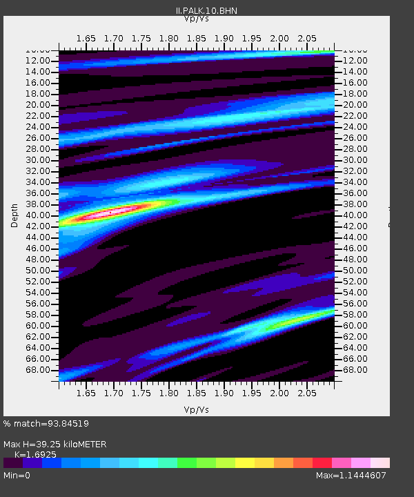
| Estimated Moho Depth: |
39.25 km |
| Estimated Crust Vp/Vs: |
1.69 |
| Assumed Crust Vp: |
6.545 km/s |
| Estimated Crust Vs: |
3.867 km/s |
| Estimated Crust Poisson's Ratio: |
0.23 |
|
| Radial Match: |
93.84519 % |
| Radial Bump: |
337 |
| Transverse Match: |
76.048836 % |
| Transverse Bump: |
400 |
| SOD ConfigId: |
2459 |
| Insert Time: |
2010-03-01 23:05:08.647 +0000 |
| GWidth: |
2.5 |
| Max Bumps: |
400 |
| Tol: |
0.001 |
|
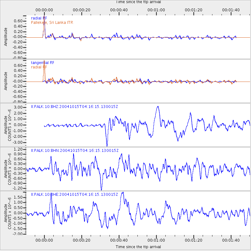
Signal To Noise
| Channel | StoN | STA | LTA |
| II:PALK:10:BHN:20041015T04:16:15.130015Z | 2.8368328 | 2.73755E-7 | 9.650023E-8 |
| II:PALK:10:BHE:20041015T04:16:15.130015Z | 7.017946 | 7.086537E-7 | 1.00977374E-7 |
| II:PALK:10:BHZ:20041015T04:16:15.130015Z | 9.980565 | 1.2594533E-6 | 1.2619057E-7 |
| Arrivals |
| Ps | 4.5 SECOND |
| PpPs | 15 SECOND |
| PsPs/PpSs | 19 SECOND |


