You are here: Home > Network List > US - United States National Seismic Network Stations List
> Station DUG Dugway, Tooele County, Utah, USA > Earthquake Result Viewer
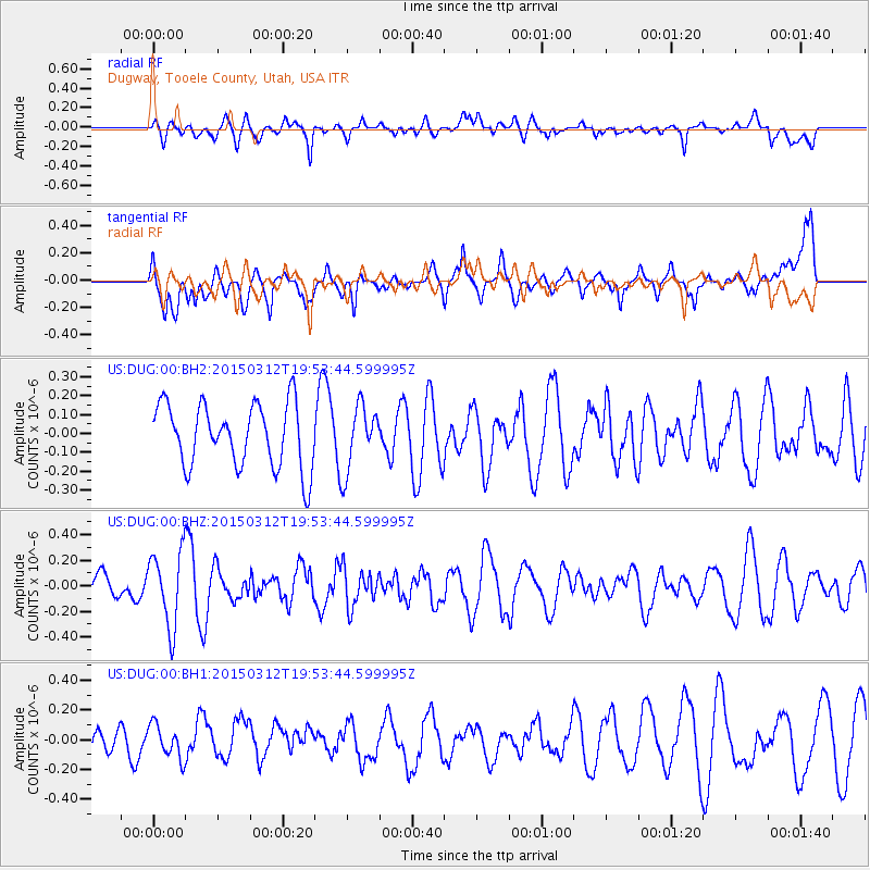
DUG Dugway, Tooele County, Utah, USA - Earthquake Result Viewer
*The percent match for this event was below the threshold and hence no stack was calculated.
| Earthquake location: |
South Of Alaska |
| Earthquake latitude/longitude: |
52.9/-162.9 |
| Earthquake time(UTC): |
2015/03/12 (071) 19:47:14 GMT |
| Earthquake Depth: |
12 km |
| Earthquake Magnitude: |
5.2 MW |
| Earthquake Catalog/Contributor: |
ISC/ISC |
|
| Network: |
US United States National Seismic Network |
| Station: |
DUG Dugway, Tooele County, Utah, USA |
| Lat/Lon: |
40.19 N/112.81 W |
| Elevation: |
1477 m |
|
| Distance: |
36.0 deg |
| Az: |
90.097 deg |
| Baz: |
307.682 deg |
| Ray Param: |
$rayparam |
*The percent match for this event was below the threshold and hence was not used in the summary stack. |
|
| Radial Match: |
48.213577 % |
| Radial Bump: |
400 |
| Transverse Match: |
49.708225 % |
| Transverse Bump: |
400 |
| SOD ConfigId: |
7019011 |
| Insert Time: |
2019-04-17 08:06:24.055 +0000 |
| GWidth: |
2.5 |
| Max Bumps: |
400 |
| Tol: |
0.001 |
|
Signal To Noise
| Channel | StoN | STA | LTA |
| US:DUG:00:BHZ:20150312T19:53:44.599995Z | 1.9948796 | 2.9082008E-7 | 1.4578328E-7 |
| US:DUG:00:BH1:20150312T19:53:44.599995Z | 1.2938274 | 1.13045196E-7 | 8.73727E-8 |
| US:DUG:00:BH2:20150312T19:53:44.599995Z | 1.0176885 | 1.7038381E-7 | 1.6742234E-7 |
| Arrivals |
| Ps | |
| PpPs | |
| PsPs/PpSs | |


