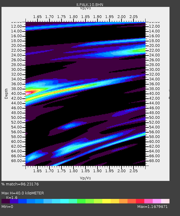
PALK Pallekele, Sri Lanka - Earthquake Result Viewer
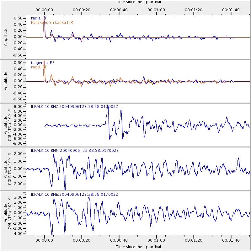
Earthquake location: Near S. Coast Of Honshu, Japan
Earthquake latitude/longitude: 33.2/137.2
Earthquake time(UTC): 2004/09/06 (250) 23:29:35 GMT
Earthquake Depth: 10 km
Earthquake Magnitude: 6.4 MB, 6.3 MS, 6.7 MW, 6.5 MW
Earthquake Catalog/Contributor: WHDF/NEIC
Network: II Global Seismograph Network (GSN - IRIS/IDA)
Station: PALK Pallekele, Sri Lanka
Lat/Lon: 7.27 N/80.70 E
Elevation: 460 m
Distance: 58.2 deg
Az: 256.883 deg
Baz: 55.392 deg
Ray Param: 0.06301536
Estimated Moho Depth: 40.0 km
Estimated Crust Vp/Vs: 1.60
Assumed Crust Vp: 6.545 km/s
Estimated Crust Vs: 4.091 km/s
Estimated Crust Poisson's Ratio: 0.18
Radial Match: 96.23176 %
Radial Bump: 373
Transverse Match: 83.24829 %
Transverse Bump: 400
SOD ConfigId: 2459
Insert Time: 2010-03-01 23:05:14.759 +0000
GWidth: 2.5
Max Bumps: 400
Tol: 0.001

Signal To Noise

ChannelStoNSTALTA
II:PALK:10:BHN:20040906T23:38:58.017002Z5.83489569.880177E-71.6932913E-7
II:PALK:10:BHE:20040906T23:38:58.017002Z8.0693681.5686021E-61.9438971E-7
II:PALK:10:BHZ:20040906T23:38:58.017002Z12.3163643.4409422E-62.793797E-7
Arrivals
Ps3.9 SECOND
PpPs15 SECOND
PsPs/PpSs19 SECOND