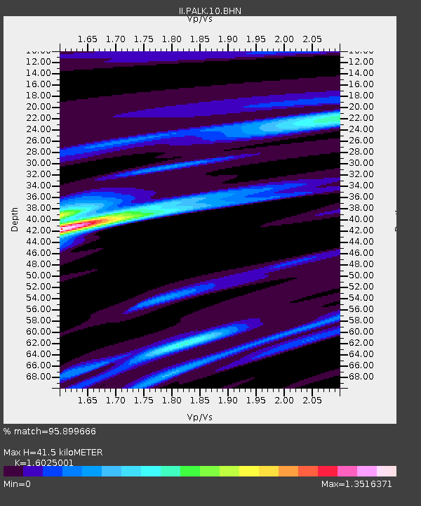
PALK Pallekele, Sri Lanka - Earthquake Result Viewer
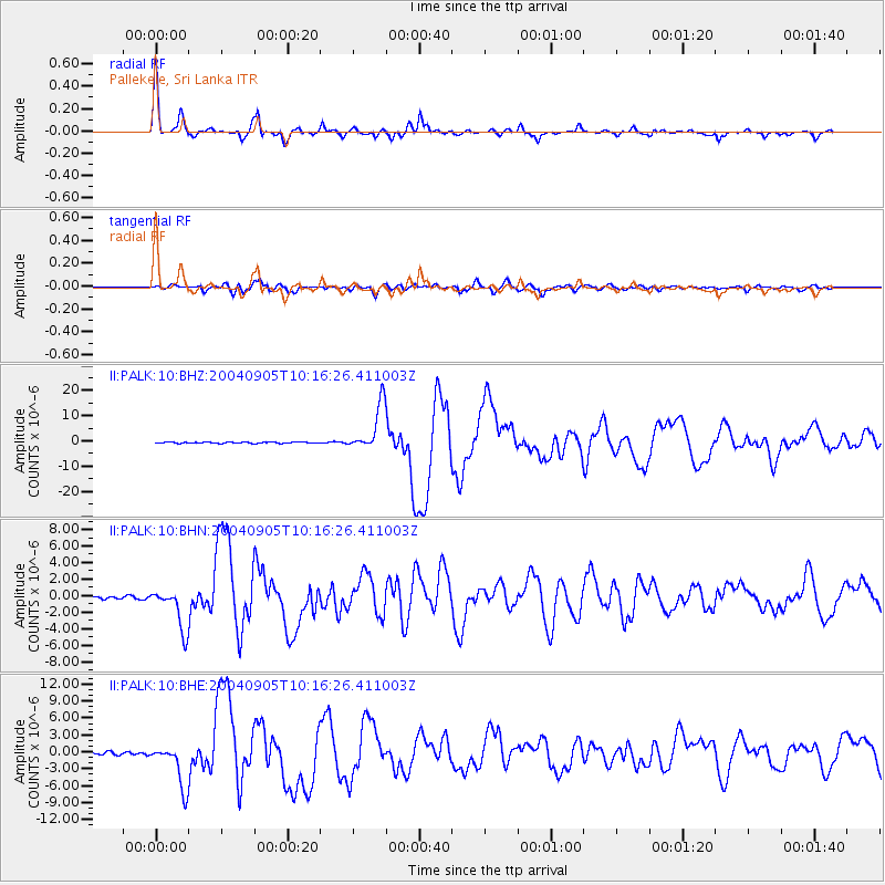
Earthquake location: Near S. Coast Of Western Honshu
Earthquake latitude/longitude: 33.1/136.6
Earthquake time(UTC): 2004/09/05 (249) 10:07:07 GMT
Earthquake Depth: 14 km
Earthquake Magnitude: 6.7 MB, 7.0 MS, 7.2 MW, 7.0 MW
Earthquake Catalog/Contributor: WHDF/NEIC
Network: II Global Seismograph Network (GSN - IRIS/IDA)
Station: PALK Pallekele, Sri Lanka
Lat/Lon: 7.27 N/80.70 E
Elevation: 460 m
Distance: 57.6 deg
Az: 256.561 deg
Baz: 55.408 deg
Ray Param: 0.06334813
Estimated Moho Depth: 41.5 km
Estimated Crust Vp/Vs: 1.60
Assumed Crust Vp: 6.545 km/s
Estimated Crust Vs: 4.084 km/s
Estimated Crust Poisson's Ratio: 0.18
Radial Match: 95.899666 %
Radial Bump: 382
Transverse Match: 86.49332 %
Transverse Bump: 400
SOD ConfigId: 2459
Insert Time: 2010-03-01 23:05:17.591 +0000
GWidth: 2.5
Max Bumps: 400
Tol: 0.001

Signal To Noise

ChannelStoNSTALTA
II:PALK:10:BHN:20040905T10:16:26.411003Z15.743992.5386898E-61.612482E-7
II:PALK:10:BHE:20040905T10:16:26.411003Z13.4238053.8649246E-62.879157E-7
II:PALK:10:BHZ:20040905T10:16:26.411003Z39.9411549.233378E-62.3117454E-7
Arrivals
Ps4.0 SECOND
PpPs16 SECOND
PsPs/PpSs20 SECOND