You are here: Home > Network List > II - Global Seismograph Network (GSN - IRIS/IDA) Stations List
> Station PALK Pallekele, Sri Lanka > Earthquake Result Viewer
PALK Pallekele, Sri Lanka - Earthquake Result Viewer
| Earthquake location: |
Vanuatu Islands |
| Earthquake latitude/longitude: |
-13.2/167.2 |
| Earthquake time(UTC): |
2004/04/09 (100) 15:23:35 GMT |
| Earthquake Depth: |
228 km |
| Earthquake Magnitude: |
5.8 MB, 6.5 MW, 6.4 MW |
| Earthquake Catalog/Contributor: |
WHDF/NEIC |
|
| Network: |
II Global Seismograph Network (GSN - IRIS/IDA) |
| Station: |
PALK Pallekele, Sri Lanka |
| Lat/Lon: |
7.27 N/80.70 E |
| Elevation: |
460 m |
|
| Distance: |
88.2 deg |
| Az: |
277.833 deg |
| Baz: |
103.43 deg |
| Ray Param: |
0.042188417 |
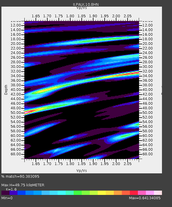
| Estimated Moho Depth: |
49.75 km |
| Estimated Crust Vp/Vs: |
1.60 |
| Assumed Crust Vp: |
6.545 km/s |
| Estimated Crust Vs: |
4.091 km/s |
| Estimated Crust Poisson's Ratio: |
0.18 |
|
| Radial Match: |
90.383095 % |
| Radial Bump: |
400 |
| Transverse Match: |
73.771545 % |
| Transverse Bump: |
400 |
| SOD ConfigId: |
2459 |
| Insert Time: |
2010-03-01 23:05:20.597 +0000 |
| GWidth: |
2.5 |
| Max Bumps: |
400 |
| Tol: |
0.001 |
|
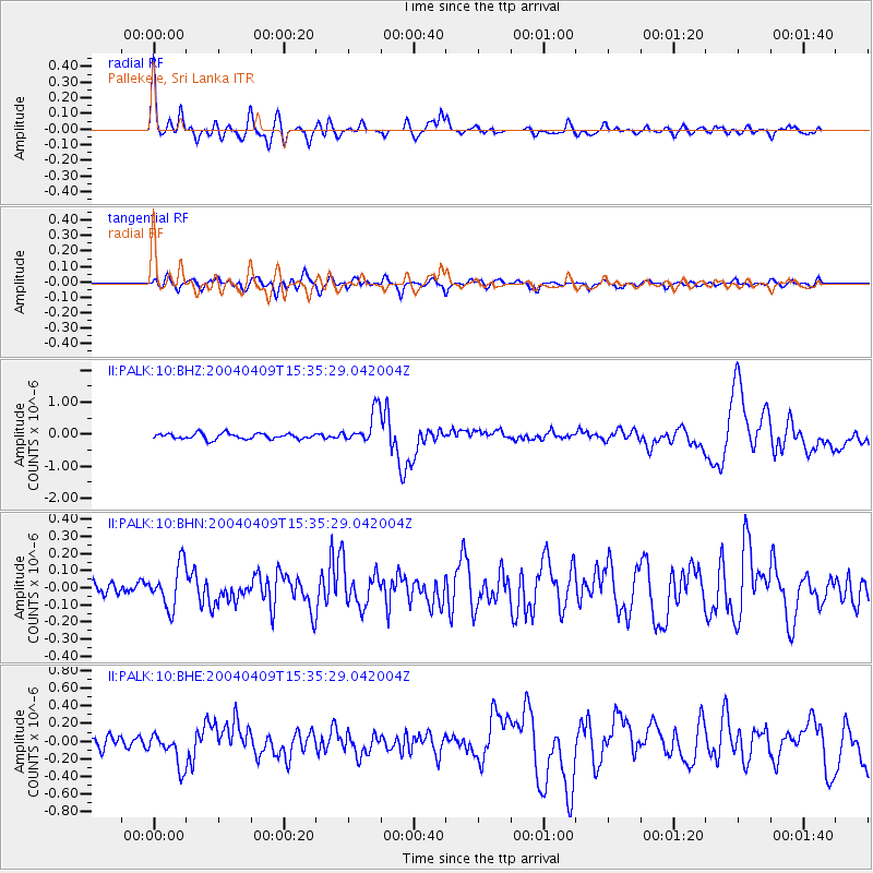
Signal To Noise
| Channel | StoN | STA | LTA |
| II:PALK:10:BHN:20040409T15:35:29.042004Z | 2.4532025 | 1.2303828E-7 | 5.0154146E-8 |
| II:PALK:10:BHE:20040409T15:35:29.042004Z | 2.9905252 | 1.8909614E-7 | 6.323175E-8 |
| II:PALK:10:BHZ:20040409T15:35:29.042004Z | 5.8430114 | 5.171489E-7 | 8.8507264E-8 |
| Arrivals |
| Ps | 4.7 SECOND |
| PpPs | 19 SECOND |
| PsPs/PpSs | 24 SECOND |


