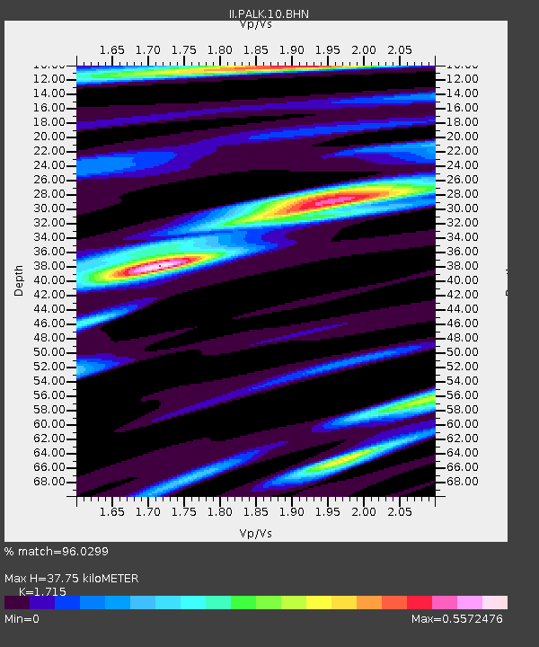
PALK Pallekele, Sri Lanka - Earthquake Result Viewer
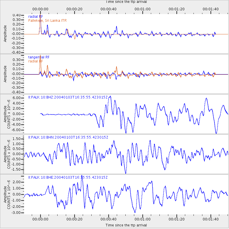
Earthquake location: Southeast Of Loyalty Islands
Earthquake latitude/longitude: -22.3/169.7
Earthquake time(UTC): 2004/01/03 (003) 16:23:21 GMT
Earthquake Depth: 22 km
Earthquake Magnitude: 6.4 MB, 7.1 MS, 7.1 MW, 6.8 MW
Earthquake Catalog/Contributor: WHDF/NEIC
Network: II Global Seismograph Network (GSN - IRIS/IDA)
Station: PALK Pallekele, Sri Lanka
Lat/Lon: 7.27 N/80.70 E
Elevation: 460 m
Distance: 91.8 deg
Az: 277.077 deg
Baz: 112.073 deg
Ray Param: 0.041554242
Estimated Moho Depth: 37.75 km
Estimated Crust Vp/Vs: 1.72
Assumed Crust Vp: 6.545 km/s
Estimated Crust Vs: 3.817 km/s
Estimated Crust Poisson's Ratio: 0.24
Radial Match: 96.0299 %
Radial Bump: 400
Transverse Match: 88.10781 %
Transverse Bump: 400
SOD ConfigId: 7314
Insert Time: 2010-03-01 23:05:26.485 +0000
GWidth: 2.5
Max Bumps: 400
Tol: 0.001

Signal To Noise

ChannelStoNSTALTA
II:PALK:10:BHN:20040103T16:35:55.423015Z2.0153772.8351383E-71.4067533E-7
II:PALK:10:BHE:20040103T16:35:55.423015Z3.4456356.003789E-71.7424333E-7
II:PALK:10:BHZ:20040103T16:35:55.423015Z15.2647862.0536224E-61.3453332E-7
Arrivals
Ps4.2 SECOND
PpPs15 SECOND
PsPs/PpSs20 SECOND