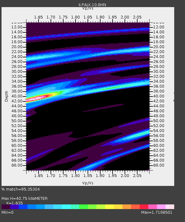
PALK Pallekele, Sri Lanka - Earthquake Result Viewer
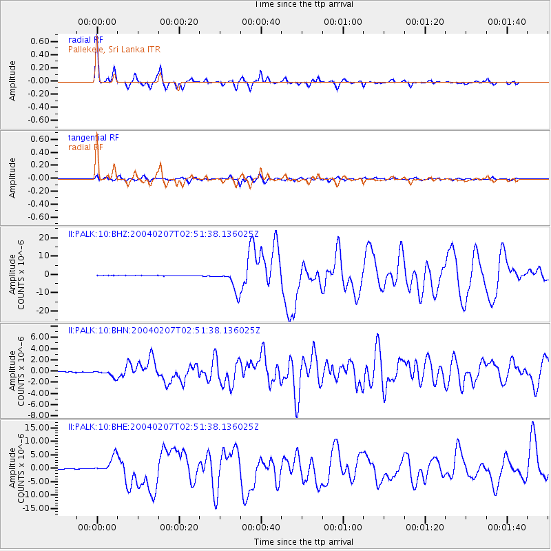
Earthquake location: Irian Jaya Region, Indonesia
Earthquake latitude/longitude: -4.0/135.0
Earthquake time(UTC): 2004/02/07 (038) 02:42:35 GMT
Earthquake Depth: 10 km
Earthquake Magnitude: 6.2 MB, 7.5 MS, 7.3 MW, 7.3 MW
Earthquake Catalog/Contributor: WHDF/NEIC
Network: II Global Seismograph Network (GSN - IRIS/IDA)
Station: PALK Pallekele, Sri Lanka
Lat/Lon: 7.27 N/80.70 E
Elevation: 460 m
Distance: 55.4 deg
Az: 281.611 deg
Baz: 99.937 deg
Ray Param: 0.06484782
Estimated Moho Depth: 40.75 km
Estimated Crust Vp/Vs: 1.63
Assumed Crust Vp: 6.545 km/s
Estimated Crust Vs: 4.003 km/s
Estimated Crust Poisson's Ratio: 0.20
Radial Match: 95.35304 %
Radial Bump: 305
Transverse Match: 81.34195 %
Transverse Bump: 400
SOD ConfigId: 2459
Insert Time: 2010-03-01 23:05:31.886 +0000
GWidth: 2.5
Max Bumps: 400
Tol: 0.001

Signal To Noise

ChannelStoNSTALTA
II:PALK:10:BHN:20040207T02:51:38.136025Z7.3798796.372265E-78.6346475E-8
II:PALK:10:BHE:20040207T02:51:38.136025Z29.6433623.1708364E-61.0696615E-7
II:PALK:10:BHZ:20040207T02:51:38.136025Z43.843856.1814044E-61.4098681E-7
Arrivals
Ps4.2 SECOND
PpPs15 SECOND
PsPs/PpSs20 SECOND