You are here: Home > Network List > TA - USArray Transportable Network (new EarthScope stations) Stations List
> Station I23K Minto, Yukon-Koyukuk, AK, USA > Earthquake Result Viewer
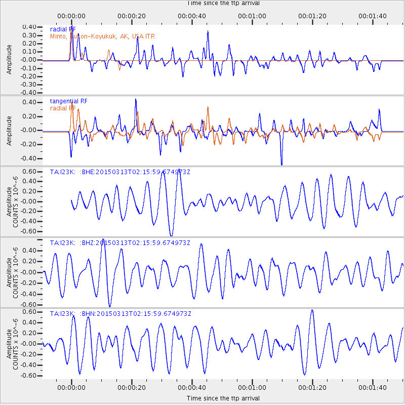
I23K Minto, Yukon-Koyukuk, AK, USA - Earthquake Result Viewer
*The percent match for this event was below the threshold and hence no stack was calculated.
| Earthquake location: |
Eastern Arabian Peninsula |
| Earthquake latitude/longitude: |
18.1/57.5 |
| Earthquake time(UTC): |
2015/03/13 (072) 02:03:10 GMT |
| Earthquake Depth: |
10 km |
| Earthquake Magnitude: |
4.2 mb |
| Earthquake Catalog/Contributor: |
ISC/ISC |
|
| Network: |
TA USArray Transportable Network (new EarthScope stations) |
| Station: |
I23K Minto, Yukon-Koyukuk, AK, USA |
| Lat/Lon: |
65.15 N/149.36 W |
| Elevation: |
149 m |
|
| Distance: |
94.6 deg |
| Az: |
11.03 deg |
| Baz: |
334.486 deg |
| Ray Param: |
$rayparam |
*The percent match for this event was below the threshold and hence was not used in the summary stack. |
|
| Radial Match: |
49.148228 % |
| Radial Bump: |
400 |
| Transverse Match: |
59.518593 % |
| Transverse Bump: |
360 |
| SOD ConfigId: |
7019011 |
| Insert Time: |
2019-04-17 08:11:17.314 +0000 |
| GWidth: |
2.5 |
| Max Bumps: |
400 |
| Tol: |
0.001 |
|
Signal To Noise
| Channel | StoN | STA | LTA |
| TA:I23K: :BHZ:20150313T02:15:59.674973Z | 1.2061508 | 1.897049E-7 | 1.5728126E-7 |
| TA:I23K: :BHN:20150313T02:15:59.674973Z | 1.5706409 | 3.5203766E-7 | 2.2413631E-7 |
| TA:I23K: :BHE:20150313T02:15:59.674973Z | 2.5284307 | 4.5601936E-7 | 1.8035668E-7 |
| Arrivals |
| Ps | |
| PpPs | |
| PsPs/PpSs | |


