You are here: Home > Network List > II - Global Seismograph Network (GSN - IRIS/IDA) Stations List
> Station PALK Pallekele, Sri Lanka > Earthquake Result Viewer
PALK Pallekele, Sri Lanka - Earthquake Result Viewer
| Earthquake location: |
Lake Tanganyika Region |
| Earthquake latitude/longitude: |
-8.0/30.7 |
| Earthquake time(UTC): |
2000/10/02 (276) 02:25:31 GMT |
| Earthquake Depth: |
34 km |
| Earthquake Magnitude: |
6.1 MB, 6.7 MS, 6.5 MW, 6.2 ME |
| Earthquake Catalog/Contributor: |
WHDF/NEIC |
|
| Network: |
II Global Seismograph Network (GSN - IRIS/IDA) |
| Station: |
PALK Pallekele, Sri Lanka |
| Lat/Lon: |
7.27 N/80.70 E |
| Elevation: |
460 m |
|
| Distance: |
52.1 deg |
| Az: |
74.378 deg |
| Baz: |
254.048 deg |
| Ray Param: |
0.066914916 |
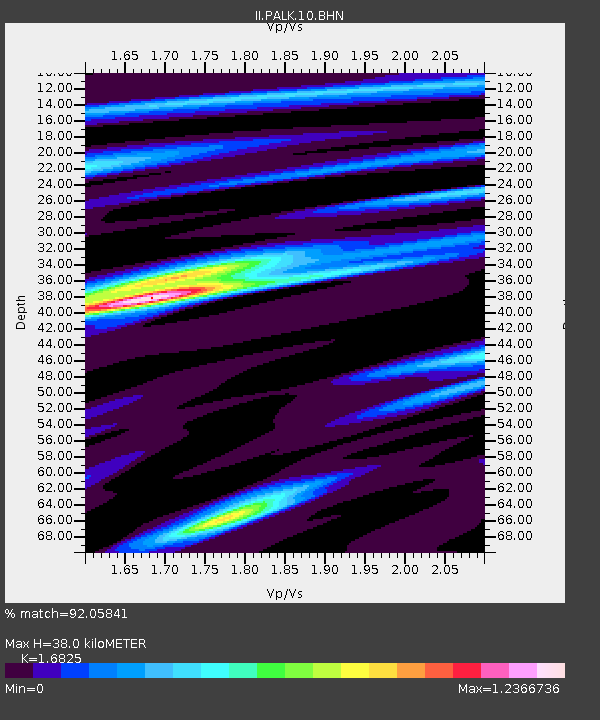
| Estimated Moho Depth: |
38.0 km |
| Estimated Crust Vp/Vs: |
1.68 |
| Assumed Crust Vp: |
6.545 km/s |
| Estimated Crust Vs: |
3.89 km/s |
| Estimated Crust Poisson's Ratio: |
0.23 |
|
| Radial Match: |
92.05841 % |
| Radial Bump: |
372 |
| Transverse Match: |
70.04793 % |
| Transverse Bump: |
400 |
| SOD ConfigId: |
3744 |
| Insert Time: |
2010-03-01 23:05:54.682 +0000 |
| GWidth: |
2.5 |
| Max Bumps: |
400 |
| Tol: |
0.001 |
|

Signal To Noise
| Channel | StoN | STA | LTA |
| II:PALK:10:BHN:20001002T02:34:07.398013Z | 0.85844517 | 1.648422E-7 | 1.9202415E-7 |
| II:PALK:10:BHE:20001002T02:34:07.398013Z | 1.0127443 | 2.0467212E-7 | 2.0209654E-7 |
| II:PALK:10:BHZ:20001002T02:34:07.398013Z | 1.2622889 | 2.2783101E-7 | 1.8049039E-7 |
| Arrivals |
| Ps | 4.2 SECOND |
| PpPs | 15 SECOND |
| PsPs/PpSs | 19 SECOND |


